Showing posts with label Woodland Drive. Show all posts

Wednesday, 2 November 2022

Absent Photo: the Tin House

 In this blog research has been made challenging in locating a house, even though it was not demolished until 1938.  In fact, there was a second building which we will refer to later.

The Tin House, circled in red, faces the former footpath from the Marshalswick Lane/Beechwood
Avenue junction.  Today's Beechwood Avenue is the broken orange line.  Today's Woodland Drive
is the broken green line.  The remaining buildings of Beaumonts Farm are close to the farm
track from Beaumont Avenue, only just visible on the left of the map,  We know it as Farm Road and
Central Drive.
COURTESY NATIONAL LIBRARY OF SCOTLAND 


The Tin House, sometimes referred to as the Iron House, is shown as occupied in the 1901, 1911 and 1921 census and continued to be lived in until the late 1930s.  It was brought to a little plot of land north of the farmyard of Beaumonts Farm; today the little house would be in the garden of 75 Woodland Drive but opening onto the footpath which Beechwood Avenue north is close to today.  The question of why such a building, a form of prefab, came to be in this location has not yet been proven.  However, the following provides a probable explanation.  Beaumonts Farm ceased to be managed by the farm's tenant in 1899.  From then on it became the responsibility of Oaklands Farm.  Beaumonts' fields continued to be utilised but lost the use of the farm homestead and any outbuildings.  Two portable structures were acquired; an early form of Nissan building, shown in the photograph below. and a family-sized single storey house also constructed out of metal.

The Nissan Hut between Beechwood Avenue and Woodland Drive and alongside Chestnut Drive.
Probably erected c1916 and in the 1940s used as a Sunday school outpost for St Paul's Church.
COURTESY SHEILA ARTISS
At the start of the First World War there was a requirement to farm the land more intensively, to replace imported foodstuffs which were in short supply.  Nissen buildings were cheap to purchase and easy to erect.  The chosen site was next to an existing track near Sandpit Lane; today it would have been between between Beechwood Avenue and Woodland Drive alongside Chestnut Drive.  In fact, its final function was the builder's yard of Tacchi & Burgess during the contract to construct the houses of Woodland Drive north and Chestnut Drive, after which c1960 it was demolished.  For a short period after the Second World War it served the growing estate as a Sunday school, an outpost of St Paul's Church.

This is NOT the Tin House described in the post, for we have no photograph of it; but is a representation of it from another location.  We know there were four rooms; the map shows a
very small external structure likely to be a toilet.
In 1901 the Tin House (Iron House) was occupied Edward Ashwell, his wife Eleanor and their daughter Sarah.  Edward was employed as a farm labourer.  In the 1911 census this role, or more specifically the cowman, was undertaken by Louis Bundy, with his wife Merrina and their four children.  By 1921 Charles Atkins, his wife Edith and five children lived here.  Mr Atkins began as a cowman on the farm, but by 1921 Mr Ivory of Townsend Farm rented one or more of the fields, and he employed Mr Atkins as a ploughman at the Beaumonts Farm. A resident of St Albans recalls seeing the tin house in the 1930s, describing its location as "in woods next to Beaumont Avenue".  This would have been shortly before the thickets were removed to create Beechwood Avenue north.  The resident knew the Tin House was occupied by the Atkins family because she was aware the children attended Fleetville School.  Charles Atkins and his wife Edith lived there with their five children.

This is the only known photograph of Beaumonts Farm homestead.  The track which became
Central Drive is across the bottom of the picture.  The road which became Woodland Drive north
will lead off to the left.
There is something else we know of the Tin House.  The tenant of the homestead, Edmund Coombe, ran a horse business there and in his retirement was an "assurances clerk".  His death occurred in 1931 and there followed an auction of his possessions.  Included in the inventory was a "corrugated iron four-roomed cottage".  We suppose it might not necessarily have belonged to Mr Coombe; it may well have been included in the auction as being no further use on the estate, then in the hands of Watford Land Limited.  The Tin House  was not sold and remained standing until 1938 when it and the farm  homestead were demolished by Arthur Welch who was about to start building houses in Woodland Drive.

So we know exactly where it was located, when it arrived and when it was demolished; also its shape and that it was constructed of corrugated iron.  According to map evidence the little building was approximately L-shaped.  Of course, we also know the names of three families who lived there during a period of almost forty years – including as many as ten children who all are likely to have attended Fleetville School.

A young group of children attending Fleetville School in 1914 when the building was no more
 than six years old – about the same age as these children.  Children living in the Tin House attended this school and one of them may even be in this group.
COURTESY FLEETVILLE INFANTS SCHOOL & NURSERY
It is probably reasonable to expect no photograph was taken of this little family home; it is only because a group photograph was taken in the late forties in front of the Nissan building that we are blessed with a partial image of the barn.  But there may be pictures out there somewhere.  For the Ashwell, Bundy and Ashwell families the discovery of such a photograph would make more complete their life stories in this part of St Albans.  And because we know the names of the children we can celebrate their lives here individually: 

Sarah Ashwell; Martina Bundy; Dorothy Bundy; Winifred Bundy, Ellen Bundy; Violet Bundy; Nellie Atkins; Louise Atkins; Charles Atkins; Arthur Atkins; William Atkins.


Saturday, 18 April 2020

Wretched Road Charges

The oft-quoted complaint by most householders, whether tenants or owners, at some point after moving into a new house before the 1950s.  Streets were laid out; water and gas mains laid – electricity and drainage only later – and homes constructed. Each owner was deemed to be responsible for the footpath and road for up to half of its width.  No-one was happy about purchasing a corner plot since that meant, when the time came for the rest of the road infrastructure to be laid, surfaced and lit, you paid twice.  Councils, which ended up carrying out these improvement works, would only agree to do so once most of the homes had been finished and occupied; possibly a period of several years or even decades.  The cost was not intended to be a charge on the rates (now replaced by council tax) and each householder received an invoice from the council for the wretched road charges – sometimes referred to at the time as private street works.

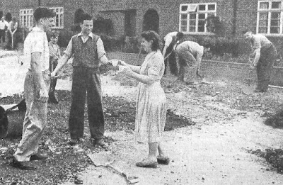
All such streets were considered private, owned jointly by its occupiers or landlords, until such time as the council had sufficient funds to carry out the work with a good chance of being recompensed through special loan schemes; the sums involved were not inconsiderable.  In the meantime, residents put up with the inconvenience of dust, mud and potholes, sometimes for several years.  The photo of a community group from Woodland Drive agreeing to carry out some of the more serious work was not unusual; it was, after all their road.

When residential development took place without regard to overall responsibility for drainage, adding more and more buildings and hard surfaces also added flooding risk.  Between the northern and southern halves of previously Spencer-owned land lies Brampton Road and its downhill gradient from the park end to Woodstock Road.  Before the houses went up surface water in periods of heavy rainfall would have found its way towards the former ancient  stream bed just east of the Woodstock Road homes, eventually finding its way to the Ver, the Colne and the Thames.

Hamilton Road today
COURTESY GOOGLE EARTH
When the water can't soak into the ground or run away safely, it might hang around in puddles and lakes, such as at the southern end of Hamilton Road.  Memories are recalled of women walking to the route 354 bus stop in Brampton Road with a spare pair of wellington boots for husbands returning from the station.  All part of the well-rehearsed wet weather routine.

In fact so long did the Hamilton Road residents have to wait that the earliest had lived there for over twenty-five years; by which time the road had been torn up to lay larger drainage pipes all the way to Campfield Road.  

Since the road was their pride the householders agreed to purchase a few small street trees.  An early attempt to take the same approach to paying for street lights [the editor knows what it was like growing up in a dark estate devoid of lighting] was more difficult to resolve, since the largest cost was in laying the cables, so a start was made from a connection from Jennings and Brampton roads; the long middle section was still dark!

A Sunday morning road mending session; Woodland Drive north in the
early 1950s
COURTESY HERTS ADVERTISER
Experiences of living in dust, mud, floods and darkness are repeatedly told in the St Albans' East End, from Camp and Fleetville, Oaklands, Marshalswick and Beaumonts, and along Hatfield Road too. The adventure living on this side of the city pervaded well into the 1960s.

Today, house builders have to do more than build homes; they must comply with standards set by regulatory bodies and local authorities, and carry out road construction, public lighting, cycle and pedestrian routes, and of course community open space, before the council signs off the development and agrees to adopt the road(s), street plates included.  Aren't we lucky?  Maybe, but that's what we have paid for.  People today moving into Osprey Drive and Austen Way won't be enduring the same fun as those from Royston Road, Meadow Close and Hamilton Road in their time. 

Saturday, 28 March 2020

Getting Noticed

Our enforced change in routines recently has been encouraging us to take more notice of our surroundings while we take our daily exercise walks.  Observations and inquiries have been received on matters such as the lettering on boundary posts, how buildings sit on their plots, the age of trees, houses which stand out, typefaces on street plates, and so on.  

One walker observed a house of post-war red-brick design among a pre-war pebbledash row in Hazelwood Drive.  To be clear, Hazelwood Drive south.  As with many homes in Beechwood Avenue south and all of Woodland Drive south this 1930s development was the preserve of builder A A Welch.  He had completed Woodland Drive south, both sides, and the odds of Hazelwood Drive south, temporarily reserving plots in each road for a work site which today would be called a compound.  A wedge shape at 1 and 3 Woodland Drive and a larger rectangle between 1 and 11 Hazelwood Drive.

Hazelwood Drive south - a post-war house nestles among the Welch-built
1930s homes; a former builders' compound.
COURTESY GOOGLE EARTH

Having completed all of the odds – but just four pairs on the opposite side – Welch began filling his compound with numbers 1, 3, 5 and 7.  That is as far as was possible before all work stopped for the war.  The sideways between the homes were shared, but the owners of 7 and 13 took an early opportunity to negotiate an extra few feet, biting into the remains of the compound intended to be 9 and 11 when they were eventually built.

Aerial phone taken in March 1939.  Hazelwood Drive is extreme right.
Rectangular builders' compound near bottom end with historic oak tree
in top left corner.
COURTESY HISTORIC ENGLAND
In the 1950s both the former compounds were finally sold for building, two houses in Woodland, but only one in Hazelwood, thanks to the narrower site resulting from the earlier land transfers.  So we have a post-war red brick home here as well as almost a complete set of evens which were more modern.  And it also answers the other question which has been posed more than once: why is there no number 11 Hazelwood Drive?

A similar query was raised a while back about house numbering in Beechwood Avenue, for which a certain answer is not clear; and for a development which progressed along the road in sequence, is rather puzzling.  From Beaumont Avenue we have numbers 1 and 3, then 3a and 5, 7 and 9 and so on.  Why was 3a necessary?  The most logical answer might come from the way the first pair face towards the junction instead of parallel with Beechwood Avenue.  It is possible the developer initially intended the first plot to be for a detached house.  The Post Office seems to have been prompt in allocating numbers, perhaps too prompt for a builder whose change of mind resulted in a pair of semis instead.  It would certainly be the reason for the resulting awkward plot boundaries and the need for a 3a in the sequence.  Of course, if there is a different account ...

Junction of Beechwood and Beaumont avenues.  Two former builders'
compounds are in this photo.
COURTESY GOOGLE EARTH

While referring earlier to builders' compounds, H C Janes, which constructed homes on the opposite side of Beechwood and in Elm Drive in the early 1930s, had a compound where number 267 Hatfield Road appeared in the 1960s.  A similar compound had been left in Beaumont Avenue which is today the location of number 2.

All that from a pair of queries resulting from everyday walks!

Friday, 19 April 2019

Only Waste Ground

There are plenty of accounts and recollections of a piece of development ground – probably enough for up to ten semi-detached homes.  It ceased to become farmland in 1929 and was nominally reserved as a site for a future church between Central, Woodland and Hazelwood drives.  During the 1930s there was, of course plenty of open space for children to play on, but by the mid 1940s when housebuilding began again "the field" became a centre of attention for a new generation of children; their very own  adventure space.

However, the field, much larger then because fewer homes had been built, was used between 1940 and 1943 by the Home Guard for training – they even had a meeting hut nearby.  One or two trenches were dug for exercises and only filled in later when house foundations were laid out in 1947.

The ground was far from level; grasses and nettles grew tall, and hiding was all part of the fun in playing adventure games.  Two badly mauled trees, previously next to the farm house which straddled Woodland Drive at that point, became their own centre of attention for climbing and swinging .  Between these trees traced the usual rough and worn path which enabled anyone to take a short cut towards, well anywhere really.


An informal game of football on the field not yet built on in Central Drive.

Out went the idea of a church; Benskin's acquired the site for a future public house, and erected a large sign to inform the world the land belonged to them.  Children saw an opportunity and used it for target practice – stones, mud, footballs.  Nearby, almost no-one noticed a square of heavy concrete which told of a former well, used by the farm.

In 1953 when just about everyone celebrated the Queen's Coronation, Woodland Drive held a street party on a part of the field where Oakwood School now stands, and in the evening the adventure field was the location for a giant bonfire and a fireworks display – this time it was the turn of the grownups to have some fun.
Team lineup with the the Central Drive shops behind.

Soon after 1960 St Albans Council's policy of making shopping more convenient for those living in residential areas, came to Central Drive and part of the field was developed for a parade of convenience shops with maisonettes above.  In time this brought a post box, and public telephone kiosk tucked around the corner of the righthand-most shop.  Not forgetting children's play, the council levelled the remaining field, and for the first time children could organise their own football games.  The worn path was still there, although foreshortened where the shops had been built.  Probably with safety in mind the Council erected one of those chestnut paling fences around the edge.  The success of the fence is doubtful, as footballs regularly soared over the top  into the roadspace, necessitating an inevitable indirect walk to the gateway to recover the escaped ball, which may have ended up in a garden, or under the only car then parked by the roadside opposite.


Irene Stebbings House replaces the open play space.

All good things come to an end sometime, and that end came with the 1970s building of the flats of Irene Stebbings House.  Today, the two trees have gone, so has the fencing intended to keep the footballs in.  There are no more opportunities for youngsters to engage in adventure games or get thrown into the stinging nettles or  ride their bikes over the uneven ground of little hills and hollows.

It was great while it lasted.

Friday, 2 March 2018

Decidedly Dodgy

There are unusual stories behind many facets of life, if only we knew where to look.  And in this case we need to look upwards.  Even then it would be difficult to notice any mismatch after nearly eighty years.

So, what might we be looking at, and where?  In this case we are looking at a group of semi-detached homes in Woodland Drive, which were constructed by the building firm of Arthur Welch.  As they were completed between 1938 and 1940, their first occupants will have felt proud to finally own their own castle.

The little story which follows is recalled as a result of old documents which have been retrieved; the kind which include letters, copies of forms, orders and receipts, from people who never threw anything away!

There wasn't an extensive aerial bombardment in St Albans during the Second World War, so those events which did exist definitely stood out, and one in November 1940 obliterated one house and severely damaged three others in Beaumont Avenue.  Four people lost their lives, either at the scene or later in hospital.
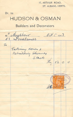
"For taking down and rebuilding dangerous chimney."

During the months which followed the householders in nearby Woodland Drive north began to notice something awry with the chimney stacks connecting the kitchen solid fuel boilers at the side of the properties.  A number of cracks began to appear; although in a few cases these cracks failed to materialise until later in the war or afterwards, even though there were no further bomb drops in the area.

Was this a weakness in the workmanship of the building company?  Or was it the Beaumont Avenue bomb blast which weakened the structures?  Of course, the builder blamed the war, and the local representative from the War Damage Department claimed a construction fault that today might have been rectified under the NHBC ten-year guarantee.

£13 in 1947.
Each householder was responsible for making his own damage claim, and inevitably not all did, partly because of the complexity of everyday bureaucracy during wartime and partly because damage, which relied on ground-level observation, did not become evident until many years later.

Once started, an inspection took place, followed by an application for permission to undertake remedial work – materials and manpower were in short supply even in the early years of Peace.  If approved, the householder then engaged a builder to provide an estimate of cost.  The War Damage Department then spent some time deciding whether the cost was within the approved limits; if so, giving its authority to proceed with the repair.  However, the bill, paid for initially by the householder, was sent to the approved insurance company.

Sorry, you're too late!
However, the householders who applied later discovered one expensive truth, no doubt contained in small print somewhere: there was a time limit on applications for war damage.  As the official letter, dated exactly seven years after the bomb, stated, the householder at number 57 was too late.  He had to bear the £13 cost of re-constructing the chimney himself.  Of the fourteen homes it is not known how many householders made applications, but most of the chimneys had been renewed by 1960 and only two or three original chimneys remained.  They seem to have survived!

Today, of course, it is likely that none of the chimneys are still in place, gone when extensions were added or modern heating systems made the chimneys unnecessary.  But if they had survived, and you looked upwards, it is just possible that you might notice a more modern piece of brickwork than the age of the house might suggest.  Ah well!