Showing posts with label Turnpike Trust. Show all posts

Sunday, 9 October 2022

Absent Photo: Original Rats' Castle

 The first in our series of absent buildings which have left no known visual trace occupied a well-known plot in Fleetville.  Mention the Rats' Castle to anyone who has ever lived in our around Fleetville and they will identify with the corner of Hatfield Road and Sutton Road.  The Rats' Castle (inevitably printed without the apostrophe) public house has been a landmark here since 1927; and there is a reason why the building sits at this spot.

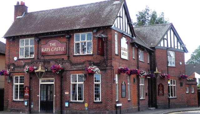
The latest of three buildings which have occupied this corner of Hatfield Road and Sutton Road.
The Rats' Castle PH opened in 1927.
When we pull out photographs of this corner we are inevitably shown a view of the current structure designed for Benskin's by architect Percival Cherry Blow and opened in 1927.  Many versions have been taken: with or without floral displays, and with one or another of several hanging signs interpreting the name of the pub using the artist's imagination.  We'll return to the name shortly.

Primrose Cottage was first a dwelling but was subsequently partly converted into a shop.  It seems
that the windowless rear extension was added at this time, with a boundary wall against the
recently converted track into Sutton Road.  Part of either 1 or 3 Castle Road can just be seen on
the extreme right.
COURTESY ST ALBANS MUSEUMS
Alternatively, a fine monochrome print of the building which the public house replaced, Primrose Cottage, completed c1895.  The title suggests it was constructed as a detached dwelling, but within two years construction work began on a large printing factory, the Fleet Works, and nearby workers' homes which were given the collective title Fleet Ville.  Until that moment Primrose Cottage was alone in the countryside, the nearest dwelling over a quarter mile away.  No time was therefore lost in converting part of the ground floor into a general store, and, as far as we know was first photographed c1903 after shop conversion under the management of Percy H Stone.

If you compare Primrose Cottage and its shop with the later public house it is possible to spot similarities in some of the design elements. There is just one known image of Primrose Cottage and shop, but I wonder whether, during its thirty year life span other views existed – still exist.

A section of the 1879 Ordnance Survey map shows the Hatfield Road (in brown) and the turnpike toll house (in red).  At the bottom of the extract is the low embankment of the Hatfield & St Albans
branch railway.  The former track, later renamed Sutton Road, then tree-lined, is between.
COURTESY HERTFORDSHIRE ARCHIVES & LOCAL STUDIES
Before either of the above buildings had existed a far more basic structure had been erected on the same footprint.  Although there is no proof of the wall materials – probably brick – we do know from recorded recollections that the roof was thatched and that it was a "little square" in floor area.  Its function was to house a turnpike toll collector (the road between Hatfield and St Albans was part of the Reading & Hatfield Turnpike Trust).  The track beside the little building later became Sutton Road and was on the edge of Beaumonts Farm owned by Thomas Kinder who also happened to be a trustee of the Turnpike Trust.  He gave the land on which the toll house was to be built and which enabled tolls to be collected before travellers set foot, wheel or hoof on the turnpike.  The track belonged to Mr Kinder and so he had a double interest in benefiting financially.  We know the toll house was erected before 1879 as the Ordnance Survey map of that year informs us, but the only known earlier record is the 1840 tithe map which is absent on the matter.

The rest of Broad Field was sold for development in 1899.  By then it was known locally as
Rats' Castle Field.  This photograph shows the upper end of Castle Road.
COURTESY HERTFORDSHIRE ARCHIVES & LOCAL STUDIES
Formally called the Hatfield Road toll house it was given up by the Turnpike Trust and continued to be occupied for a time before being abandoned by 1890.  It became rat infested, the rodents making their  homes in the straw roof.  Passers by had already given it a nickname by the time of the 1891 census: "the rats' castle". The building was identified as such in the 1891 census, and the field in which it stood, previously known as Broad Field, was known as Rats' Castle Field.  When in c1899 houses were built on part of the field the road was named Castle Road.

While we have been able to build a story based on those facts available to us no-one has brought forward a photographic image or a reasonably accurate pencil drawing or water colour painting.  We know where it was located from map evidence but we are badly in need of a photograph or drawing.  Let's get searching.

For further details of the above buildings on this site:

http://stalbansowneastend.org.uk/topic-selection/rats-castle/


Friday, 8 February 2019

How many miles?

Find a drawing of of Dick Whittington, probably with cat as part of the story, and the picture will probably include a milestone  "How many miles to London?"  Our mind's image of any open road, in the days before motor vehicles, will probably include these stones.  Although they were likely to have been placed along some highways before the days of Turnpike Trusts in the 18th century, when it became a legal requirement to install them, it is the turnpike roads we most associate them with today where they still exist.

Here are three brief references to them on the Turnpike Road, now Hatfield Road, as it passed through Fleetville.  


From Fleetville: four miles to Hatfield, and
later 13 miles to Ware.
You have, no doubt, spotted the mile marker at the corner of the recreation ground at Royal Road.  When it was first manufactured in the 1760s it wasn't planted in this spot; it first measured the fourth mile from Hatfield about a hundred yards further east, roughly where Simmons, the baker is today in Bycullah Terrace.  Even after the shops were built c1900 the marker was tolerated in its rightful place until the 1920s – we're not sure exactly when.  It was then deemed to be "in the way" and languished in a storage depot somewhere until it saw the sunlight once more in a more convenient location.


An extant mile marker on the road to Ware,
manufactured by a different trust.
You may have thought that someone, at some time, defaced the surface of the Fleetville mile marker on the east facing panel.  Since Hatfield was the next town it is probable that this panel had always been blank.  At some time during the lifetime of the Trust it probably took over responsibility for the road onward to Hertford and Ware, and provided helpful mileage information beyond Hatfield.  Painting the details on was much cheaper than casting completely new markers, but whatever paint was used, the handwritten characters have certainly lasted much longer than the metal paint on my garden railings!

Today, it is difficult to imagine the true width of these old roads, and when we boast about the modern width of Hatfield Road it has only been engineered that way in modern times.  So here is an example of an unwidened section, although it is not in the East End of St Albans.  Almost no-one drives along the Old Watford Road today to reach that town; we have a wonderful dualled-carriageway nearby which better serves our needs.


Old Watford Road where a toll gate had been located.
In turnpike days this WAS the Watford road, and on the right in this image, where modern homes have been constructed, had previously been sited a turnpike gate, where travellers paid for the right to use the next section of road as far as Hagden Lane, Watford, or in the other direction, the Peacock PH.  There is no evidence that the road width has been narrowed since the 1880s when the Old Watford Road became a public highway.

To hear more facts, urban myths and – as Dr Lucy Worsley likes to playfully suggest – "fibs",  Fleetville Diaries has an illustrated presentation about the Reading & Hatfield Turnpike Trust on Wednesday 27th February at Fleetville Community Centre; coincidentally one hundred metres from the Fleetville mile
marker!  Further details on the Welcome page of www.stalbansowneastend.org.uk


Friday, 30 March 2018

Pothole Alley

With a title such as this you could be preparing to read a thoroughly modern story about the state of our roads and the inadequate amount of funding available to do a proper job in maintaining  thoroughfares and residential streets.

The state of our roads debate is probably as old as the proverbial hills.  Hatfield Road is in a variable condition at present, with entire slabs of macadam broken away like giant broken biscuit, and a few jolts here and there sufficient to wake a dozing passenger.

In the years leading to 1881 there were reports of a similar neglect of the road's condition, complaints at the authority responsible for receiving funds through the turnpike tolls, and then not spending it on repairing the road.  

The Reading & Hatfield Turnpike Trust was not considered to be very effective body at the best of times, but it did its best, at least until its final few years when closure was inevitable and take-over by a public authority.  Neglect set in, and it's anyone's guess where the income was spent.  The pictorial evidence?  The 1870s and 1880s are within the realm of early photography, though not with the popularising of techniques thirty years later.  Nevertheless, no identifiable early plates appear to have survived, if they were ever produced.  We might otherwise be able to publish spot the difference images in the newspapers!

There are many residents who will recall other potholes, although at the time of their experiences the route was on private land along a permissive way.  Who remembers The Ashpath, aka The Cinder Track?  A cart driver originally beginning at Hatfield Road, opposite Beaumont Avenue, would be pitched and jolted on his vehicle all the way to a bend close to the present Cambridge Road.  The only relief came when the horse pulled the load up the steeper gradient to pass a humped railway bridge (its modern version still takes traffic across the former railway across Ashley Road).  

When the homes on the Willow estate were built in the early 1930s the first section of the Ashpath was made up.  Our memories remain, however, of the next section.  It was wide, but there was a fearsome collection of variable holes along the whole length of the road.  After rainfall it was not possible to walk in a straight line for more than a few yards.  

Modern factories replace old Nissen huts near Hedley Road; the
former brush factory to the right, behind the hedge.

The owner, Thomas Kinder, had died in 1881 (coincidentally the year the nearby Turnpike was taken over), and from then until the 1960s when the City Council created a road out of the mess, it appeared to be no-one's responsibility.  Holes were occasionally filled with ash from the brick ovens on the east side.  Which brings us neatly to the same question posed above.

The first modern building along the Ashpath replaced the
former Owen's brickworks.
What visual evidence remains of the Ashpath as it used to be between the early 1900s until the 1960s?  The brickworks and subsequent quarry holes, eventually used for tipping rubbish?  The brush factory spewing out wood shavings and sawdust beside the track?  The large Nissen huts between Hedley Road and Cambridge Road, both of which joined the Ashpath in an uninviting way?  The ancient oak tree, only recently removed?  The bend where the path continued to the entrance of Hill End Hospital?  The latter remains as a much narrower way than in its earlier days.  Or the temporary pedestrian bridge slung over the cutting while the old bridge was being replaced?  Finally, where is a photograph of the brickworkers' cottages opposite near the end of Cambridge Road?

Photos of modern industrial estates are all very well.  But those irritating obstructions along pothole alley and the activity which grew up around them, are now limited to descriptions on the page.