Tuesday, 21 February 2023

Marsh

 If you have ever walked along Sandpit Lane – all of it from Sandridge Road to Coopers Green Lane – you will have made at least one observation, that the lane is remarkably straight, in the same way we vision a Roman road to have been straight.  Today, we are pausing close to the roundabout which gives access to the Jersey Farm residential district.  Before the houses came you walked a narrow lane towards the farm and onwards to Sandridge.  But for the moment we will stop at the roundabout.

The couple of hundred metres of House Lane did not exist exactly here before the houses arrived.  Most of the original line of House Lane can still be seen, but it meets Sandpit Lane obliquely behind the three cottages known as Ardens Marsh.

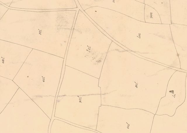
A section of the 1840 tithe map showing the location of Ardens Marsh.
COURTESY HALS


The cottages are revealed on both the 1879 and 1896 surveys (this is 1896).
COURTESY NATIONAL LIBRARY OF SCOTLAND

Sandpit Lane follows the bottom edge of the photo.  An upgraded House Lane skirts the modern
housing to a new junction with Sandpit Lane; the former section of House Lane now remains to the north of the cottages.  Some of the houses are built within Ardens Marsh; those on the extreme left in 
the former Ardens Marsh Field.
COURTESY GOOGLE EARTH.

The 1840 tithe map identifies this junction clearly.  We need to look for field number 246.  The map here is very close to the parish boundary, and since it is essentially a parish map nothing of the land north of the broken line – that of Sandridge St Leonard – is shown.  As usual the tithe maps are not oriented northwards but have been moved a quarter turn for a best fit.  Sandpit Lane crosses the lower part of the map before turning towards Smallford.  Today its name is changed to Oaklands Lane after the Coopers Green Lane junction.

Field 246 is different from others on the map in that it is unfenced on the two sides where Sandpit and House lanes pass.  House Lane, incidentally, was at one time known as Hatfield Lane, but possibly not at this end.  The field was named Ardens Marsh, and the rectangular field to its west Ardens Marsh Field.  In the second half of the 19th century these two fields were combined.

View towards Sandpit Lane; the edge of Ardens Marsh.


Ardens Marsh cottages.


The name Ardens is obscure, and has been alternatively known as Hardings – the comparison is logical.  But the Marsh in the name is not as obscure as all that.  This locality lies low in the chalky landscape, a fact made clear as anyone climbing northwards along Coopers Lane will testify.  North along the line of Sandpit Lane, when the water table was significantly higher, have historically appeared a number of springs.  Only Ellenbrook and Boggy Mead Spring remain as surface streams today.  Ardens Marsh was still grass in the 1840s, and even today the roadside ditches are often water filled.

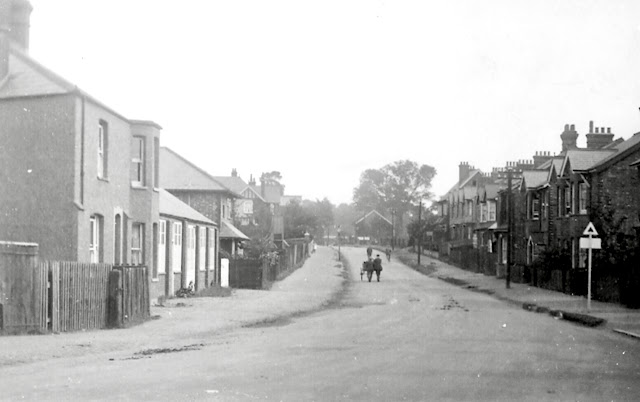
House lane as it was in the early 1900s looking southwards from Sandridge.  This section was known as Hatfield Road or Hatfield Lane.

Between the roundabout and the stub of House Lane which no longer provides access to Sandpit Lane, are the three attached cottages which are collectively called Ardens Marsh.  They didn't exist in 1840 but do appear on the 1879 survey.  Other nearby farm employee cottages were built during the same period: Freelands in Coopers Green Lane, Newgates in Sandpit Lane, Hall Heath also in Sandpit Lane and Beaumonts in Beaumont Avenue.  The need to accommodate key workers and improve on earlier and highly unsuitable arrangements of temporary accommodation within the conglomeration of inadequate farm buildings.  Ardens Marsh cottages were erected and owned by Thomas F Gape, who also owned the nearby Oak Farm.  His land extended to the western end of Ardens Marsh Field, abutting the small and narrow Newgates Farm.

Ardens Way is this locality's connection with the past.

Ardens Marsh carries its name forward to the future as well, for a residential road branching off Barnfield Road has been named Ardens Way.

Tuesday, 14 February 2023

Crown Fields

 Before launching into this week's group of fields you might like to return to last week's post, Nine. I had intended to add an early Fleetville advertisement for Carter's (Sear & Carter later).  After much searching I have finally located it and it takes its place in the middle of the previous post.  Frank Carter located his shop and the adjacent land in Hatfield Road next to St Paul's Church as Ninefields Nursery.  The site of this property is now St Paul's Place.

IT might take some time to identify your location from the tithe map.
COURTESY HALS


The tithe map with roads named and fields identified.  The text below lists the owners by their
printed colours.
COURTESY HALS


This week there is a far larger group of fields (above) to understand if we are to make sense of the district which launched the development after the 1879 expansion of the city's boundaries, from the previous 1835 Lattimore Road boundary as far as the Midland Railway and Crown junction.

Again I have begun with the 1840 tithe map which, as always, is bereft of helpful text labels; just roads, field boundaries and their numbered references, and properties in grey or pink.  So, the first version at the top is how we start, and once the roads have been identified by their curves, straights and junctions, the names of the fields and their owners can be added.  In this locality there are many owners, identified by colour.  We should wonder whether owners sold up enthusiastically, willingly, or following detailed deliberations and only persuaded after offers of a higher price.

The blue fields were those of William Cotton of St Peter's Farm; the purple fields were owned by Thomas Kinder, but away from his Beaumonts Farm; in red were the fields belonging to Edward Boys.  One field, in grey was owned by Widow Brown, who also had a connection with St Peter's Farm, that field being between today's Marlborough and Lattimore roads.  Of the two major land owners Earl Verulam's presence on the map are in orange, while two fields owned by Earl Spencer (and rented by Thomas Kinder) are shown in green.

The map surveyed in 1872 just a handful of years after the building of the Midland Railway.
COURTESY NATIONAL LIBRARY OF SCOTLAND


Map surveyed in 1897.
COURTESY NATIONAL LIBRARY OF SCOTLAND

Map surveyed in 1922.
COURTESY NATIONAL LIBRARY OF SCOTLAND


The Ordnance Survey map surveyed in 1872, forty years after the tithe map, demonstrates the sheer expanse of railway development once it arrives, and on this map are two; the Midland between north and south and the diagonal route of the Hatfield & St Albans branch line.  By this date street development had grown apace so Boys' fields were quickly lost under houses, as are two of Kinder's.  Locals knew this expansion area as New Town.

By the time the 1897 map was surveyed two further developments had appeared on the eastern side of the Midland Railway, touching and over-reaching the new 1879 boundary.  The field known as Nine Acres (not to be confused with Ninefields from last week) first became a nursery before being purchased by Frederick Sander for the Cavendish estate in 1880.  The opportunity arose as soon as the Midland Railway opened, to develop homes for users of the railway (commuters?).  Therefore, Stanhope, Granville and adjacent Hatfield roads were opened up in the 1880s and 1890s.  Earl Spencer, as with all major landowners, made a profit on his resources, and a field did not need to grow crops if a better income could be made From other outputs.  Land owners are not necessarily farmers.

Meanwhile, three more fields owned by Earl Verulam to the south of the map were also up for grabs.  Twelve Acres quickly became the prison at the same time as the Midland Railway arrived, the remaining land on this field becoming known as the Gaol Field and subsequently developed as the Breakspear estate.

Camp Road today, facing uphill to Camp Hill; the route of the former branch railway passing
overhead (but not on this newer bridge).  Originally the lane followed a line further to the right,
but to provide sufficient height it was diverted eastwards as shown on the 1872 map (above).

Camp Lane, on the lower edge of the map, was diverted by the builders of the branch railway route.  Its two adjacent fields, Dell Field and Up And Down Field were pastured until the 20th century and succumbed to housing development from the 1930s as the Dellfield estate.

It is not difficult to use the tithe field boundaries to compare them with the three Ordnance Survey maps for 1872, 1897 and 1922;  many of those boundary lines are still evident in current roads, tracks and footpaths, the edges of gardens and other properties; a fascinating tracing of the locality's progress through the 19th and 20th centuries.

Sunday, 5 February 2023

Nine

 When growing up in the 1950s, I came across grown-ups who were well settled into their Fleetville lives (as a child I would have used the word 'old') referred to a non-specific part of the district as Nine Fields, or the Nine Fields.  It has taken decades to home in on the background to this name.

Sear & Carter, who had a garden shop and nursery in Hatfield Road, on the site of today's St Paul's Place, had named it Ninefields Nursery.  So likely it was close by to this group of open space fields.

A class of boys from Hatfield Road Senior Elementary School at work with their teachers on
the land north of Brampton Road in 1917.  Early work to prepare wartime allotments for their
families.  The south side of Brampton Road is in the background.
COURTESY HERTS ADVERTISER


The beginning of the article which accompanies the
photograph above it.
COURTESY HERTS ADVERTISER


Frank Sear (before becoming Sear & Carter) advertised its Hatfield Road shop and adjacent land
as Ninefields Nursery.  The nine fields, however, were north of Brampton Road.

The Herts Advertiser in 1917 ran an article about senior school pupils who had taken on extensive plots of ground "at the Ninefields" for wartime allotments.  The boys (the item was specific here; no girls were mentioned) would take home produce which they grew to their families. In one of the earliest photographs published in the paper the image was spread over the whole width of the page but there was little height to it.  The photographer was probably standing close to where Jennings Road is today, facing south so as to capture large numbers of boys at work, with the south side of Brampton Road beyond.

An uncle, who had grown up in one of those Brampton Road terrace houses, recalled his childhood adventures playing "on the Ninefields at the Woodstock Road end".

With a copy of the 1840 tithe map in front me I annotated that section between Beaumonts and the then city boundary and between Hatfield Road and Sandpit Lane.  Unfortunately I didn't manage to join the split map very effectively. 

The field names might, I thought, provide a clue to the name Nine Fields.  Descriptive as they were, the field names led me no nearer to an answer (except for one field named Nine Acres!)  Perhaps I should look at field names in more detail.  One group focused on locations and general descriptions of shape, such as Further Field or Great Long Field.  A pair of the largest fields in the Sandfield Road/Verulam School area was named Great Moodys and Long Moodys, which suggests an old English reference to fields which are difficult to work, unless someone has a more specific suggestion.

The orange labelled fields belonged to William Cotton of St Peter's Farm. The
unlabelled fields on the left are part of the map below.  Kinder's fields of
Beaumonts Farm and the Grammar School Field, on which Fleet Ville was
built, is not part of this survey.
TITHE MAP COURTESY HALS
A third group defined the fields in terms of their size in acres; there is Four Acres, Seven Acres and so on.  I noted that the group 1 and group 2 fields in 1840 were both owned by William Cotton of St Peter's Farm, whose farmhouse still exists as the Conservative Club, near The Crown.  Group 3 fields all belonged to Earl Spencer.  There were twenty fields in total.  Mr Cotton's apportionment was eleven fields, including the smallest, the almost circular Dell Field, a former chalk pit.  However, Spencer's total was 9 fields – so, to spell it out, Nine Fields.

The green labelled fields belonged to Earl Spencer; the orange labelled
fields belonged to William Cotton of St Peter's Farm and are additional
to his fields on the top map.  The two unlabelled fields lower right appear
on the top map and are labelled on that version.
TITHE MAP COURTESY HALS
The Nine Fields were a contiguous group, all north of Brampton Road, six of them with a boundary to Sandpit Lane and the remainder completely road-locked but edged by the lengthy footpath between Hatfield Road/Beaumont Avenue and St Peter's Church, much of which was adopted by Brampton Road and York Road.

So, although the Nine Fields must have been a specific group which did not include fields in the vicinity of Woodstock Road, it seems that the name became more generalised to refer to all of the fields between Brampton Road, Woodstock Road, Sandpit Lane and Clarence Road; quite possibly a slightly larger area before early 20th century developments.

References to Nine Fields in published works are virtually absent – but then, very little about the eastern districts of St Albans has been published anyway.  If, however, readers of this blog are in possession of more definitive information, please to share it with us.

Saturday, 28 January 2023

Hither and Further

 In the previous post we identified three former fields grouped around or near the double roundabout at the heart of the Beechwood Avenue and Hatfield Road junction – a very busy and sometimes congested traffic meeting point.  To name the fields as they were prior to building development and when active farmland we'll take a walk eastwards  along Hatfield Road, beginning at the Bycullah Terrace Fleetville shops.  

View east along Hatfield Road from Sutton Road (off camera to the right).

Our first field on the right, beginning at Sutton Road and extending to Ashley Road was named Broad Field.  Today's Cambridge Road marked its hedge line with parallel Hatfield Road, though it was the railway which became the foreshortened boundary from the 1860s. Although by the second half of the 19th century Broad Field was identified as part of its partner, Hither Bridge Field; the track, now Ashley Road, divided the two sections.  It is possible these two fields were merged for convenience.  They were both considered arable, and they were both intended for sale for development together by 1899, although the latter was delayed until 1929. They had nevertheless been together referred to as Broad Field. Around c1890 the part of Broad Field furthest west was referred to, possibly informally, as Rats' Castle Field.

The fields laid out over today's street map.
OPEN STREET MAP CONTRIBUTORS

Continuing from Ashley Road on our eastwards walk an altogether smaller field, Hither Bridge Field, had its Hatfield Road eastern hedge line at the highest elevation where the main road levels out.  While Beaumonts Farm, with a line of mature oak and beech trees which continued on our left, there is a change of ownership on our right.  Hill End Farm named this field Hatfield Road Field, with a plain-enough meaning! As with the previously mentioned fields this was described as for  arable use, and was only sold – by the Hill End Hospital as surplus to its requirements – in 1920.

From right to left, passing Ashley Road, which was a track; then up the gentle hill passing Hither Bridge Field along Hatfield Road; towards Hill End Farm's Hatfield Road Field.  Off the picture on the
left is the former Three Corners Stewards Field, which today includes Elm Drive.
GOOGLE STREET VIEW

While we have been walking towards Oakwood Drive, the field on our left behind the shield of roadside trees and part of Beaumonts Farm was called Three Corners Stewards.  It certainly has three sides and therefore three corners.  Steward is someone who takes responsibility for something, in this case perhaps not the field itself but at the farm or manor.  It has an Old English early medieval derivation with the first part of the word referring to a hall – an early style of manorial building.  We note that the nearby area of Sandpit Lane is still referred to as Hall Heath.

If you were wondering about the bridge included in the name Hither Bridge Field, you may be similarly perplexed about its neighbour, which today is part of Brick Knoll Park business park; it was formerly named Further Bridge Field. The bridge in question had nothing to do with the branch railway, but there may have been a simply formed bridge somewhere near the boundary between the two fields.  We have to follow the contours and remember that below the clay there is chalk.  Though the water table is not as high as in previous centuries it is likely a spring surfaced nearby and followed the natural land surface in the vicinity of Cambridge Road, meeting another stream flowing from The Wick, across Hatfield Road and Campfield Road towards the River Ver, thence to the Colne.

When building development first began in 1899 your walk along Hatfield Road would have begun with the general shop on the corner of Sutton Road, where now is the Rats' Castle public house; the route  of Castle Road, with its two sub roads Cape Road and Kimberley (later renamed Burleigh) Road, had been laid out and one or two groups of homes and a few isolated cottages built, or in the process of construction, by 1905  A little nursery garden had quickly grown near the Ashpath track, but the remainder was left as open land.  Even along Hatfield Road where housebuilding was slower off the mark.  The field appears to have been initially purchased by two different businessmen: Tom Tomlinson and Horace Slade.  As with other early development in Fleetville the roads were lined with a mix of houses and business premises, although there has been slow transformation away from workshops in favour of compact homes and small groups of flats, the most recent only coming out of the ground within the past twenty years.

Further Bridge Field east of Ashley Road was retained by the Fish family of Oaklands (who had acquired Beaumonts Farm c1899).  The owner had released some of the remaining field as an allotment garden, but not the Hatfield Road frontage.  There was space for approximately seven homes here but the plots did not become available until 1929, all but one completed by 1931. At the same  time homes for rent were built on what is now known as the Willow Estate.  This included a row of homes on the east side of newly named Ashley Road, completing the first phase of road names with the theme of trees.

On the former Hill End Farm's Hatfield Road Field, building had begun earlier; three were complete by 1923, twelve more by 1926, and the remainder by 1930.  As with all homes in this period only the plots were purchased, leaving the owners to negotiate separately with a builder; a majority of the homes became detached dwellings, mainly having substantial rear gardens.

Across the main road Three Corners Stewards became part of the remainder of Beaumonts Farm to be sold in 1929.  So a line of large semi-detached homes became the subsequent development along Hatfield Road, the first to be marketed as "an estate".  Many of the line of mature trees along the Hatfield Road frontage of Stewards had conveniently been removed during or shortly after the First World War, the work carried out under supervision by prisoners of war billeted at Oaklands.  The boundary near the Beaumont Avenue end was in the form of an embankment, out of vertical alignment with the road surface – and there was no footpath for several years.

Both sides of Elm Drive were within the curtilage of this field and marketed between 1933 and 1936.  For those pondering over a distinctly more modern house at the junction of Hatfield Road and Beechwood Avenue, this was built c1966 on the site of the builder's compound for the field's development.

Monday, 16 January 2023

Old Field Names

 Readers will have noted over the years in which this blog has been published that old names for specific locations have been labelled using the names of fields on which, in the end, development had taken place.  Of course, very few people will understand what these names are, or were, and there is only one database which is anything like a complete national reference.  If you are to consult a 19th or 20th century Ordnance Survey map you will discover that fields are given numbers, although the same fields in subsequent surveys are provided with different numbers, which is not always helpful!  The reason is, in part, because during the intervening period land owners or tenants may have separated existing large units into smaller fields, conversely amalgamated smaller fields into larger hedged or fenced areas, or whole farms amalgamated.

The next three map extracts illustrate the issue nicely.  

The above map shows Hatfield Road, coloured brown, at the top, and the Hatfield and
St Albans branch railway further down.  The Avenue (Beaumont Avenue) joins Hatfield Road
and then continues as a track towards the foot of the map.
25 inch OS map surveyed in 1872.
ALL THREE MAPS COURTESY NATIONAL LIBRARY OF SCOTLAND


The second map show the same fields on the 25 inch OS 1897 map.


The above map again shows the same fields on the 25 inch OS 1922 map.


On each map the west-to-east road is Hatfield Road with the former Sutton Road turnpike toll house on the extreme left and the junction with the privately-owned Avenue (later Beaumont Avenue) halfway along.  The Hatfield & St Albans branch railway (now Alban Way) disappears off the bottom of each map.  The broken double lines in the top two maps mark the track formerly known as The Ashpath or The Cinder Track linking the Beaumont Avenue junction with the railway bridge and then leaving the bottom of the map.  This track had been made into a road by 1922 and was renamed about this time as Ashley Road.

By reference to the 1872 map the large field which the track intersects is numbered 480 (with an area of 27.538 acres).  By 1897 the same field is numbered 806 and with an almost exact acreage.  But by 1922 the field, by now renumbered 294 is significantly smaller as the western half was sold for development in 1899.  Its working area is down to 13 acres.

The second field to look at in 1872 is east of the first one. Again, each survey numbers them separately. Because, as one sheet of a fuller map we can only see the western part of the field, the area of the complete field number 496 is shown in the margin: 21.212 acres.  The field boundary between those two fields also separates two farms: field 480 belongs to Beaumont's Farm owned by Thomas Kinder, and field 496 is part of Hill End Farm owned by the Gaussen family.

An event in 1920 is recognised in the third map above.  The owner of Hill End Farm from the 1890s was Hertfordshire County Council as owners of Hill End Asylum.  However, the council did not require to use the whole farm, and it therefore chose to dispose of the fields on the Hatfield Road frontage for development.  This is illustrated on the 1922 map where plots are already pegged out and two houses are already complete, the one at the right margin being close to where Oakwood Drive was later laid out on the opposite side of the road.

The third field to pinpoint is on the north side of Hatfield Drive and entirely part of Beaumonts Farm: field 484 (in 1872), 367 (in 1897) and 4 (in 1922).  Although we can't see the northern boundary on these maps, we know that something has changed, as its acreage has reduced from nearly 20 to just under 12.  The northern boundary when the farm was sold in 1929 roughly followed the line of today's Elm Drive.

1840 tithe map covering the same area, although a little extended.  The later railway can be
traced through hedge lines on the west of the map.
COURTESY HERTFORDSHIRE ARCHIVES & LOCAL STUDIES

Finally, we'll look back to the map series before the 1872 edition.  Although remarkably well drawn it did not contain as much detail and shows evidence of more basis construction.  It was created in 1840 for this part of Hertfordshire and is widely known as the Tithe Map, considering the purpose for which it was created.  The Award (a written listing) names all of the fields, buildings and other enclosed areas of land, the owners and occupiers, size of enclosed areas from which to calculate value, and the purpose for it was used – payments due to support the church and its organisational structure.  The tithe map was created with east towards the top; when comparing with other maps therefore I have turned the map through 90 degrees – which is why the field numbers are shown printed on their sides!

Notice that the fields were named, not numbered.  But the names are likely to have retained their names over a long period of time, and the record of these was limited to the tenant and landowner accounts and working books.  In some case the names related to topographical features, sizes and nearby features, bearing in mind that not all tenants would be in a position to read or write their own records.  We might not always appreciate the relevance of the names today, but we will reveal more in the next post.

The names of our three fields in 1840 were:

Field 480 in 1872 - Hither Bridge Field (field 738 and 737)

Field 496 in 1872 - Hatfield Road Field (field 718)

Field 484 in 1872 - Three Corner Stewards (field 207)

It is these names I tend to use as they are more meaningful than frequently changing field numbers, and they are more likely to linger in the agricultural vocabulary.  In fact, many current street names are derived from former field names.

In the next two posts I'll explore each of these three fields and how they have changed in more detail.  For a start, we might discover how each of these fields was used when they were part of a farm, and  the nature of the change which occurred to made them a complete  part of modern Fleetville.


Sunday, 1 January 2023

The Year Was 1922

 Almost every newspaper and magazine – and these days blogs as well – features a roundup of the past year's major events.  During the past decade such a topic has only occurred occasionally on this blog; so 2022 is one of those years!  Here goes: one hundred years ago, and what had been the talking points in Fleetville and Camp districts in 1922?

Not a particular feature of 1922 alone, but one which engaged a number of residents who enjoyed regular walks in the countryside or in their newly-built homes near to woodland: the battle between the resident red squirrels and the invasive greys that had spread their range remarkably quickly.  Correspondents to local newspapers claimed to identify where a grey squirrel had been from the damage to bark it had left behind.

The phrase "Homes for Heroes" had been around for four years.  Such a reward for returning soldiers after the First War was widely acknowledged, but by the end of 1922 only one local scheme had been taken forward, at Townsend.  But In our East End the Springfield site was still empty, with rumours from the government that funding for HFH schemes was soon to be cut back.  We were to live in hope and expectation.

Those of us who enjoyed watching our city's football team playing on home turf at Clarence Park received some welcome news that plans were afoot to provide some spectator shelter along the railway side of the ground, and a volunteer force of men were engaged to construct terracing using secondhand railway sleepers to provide improved visibility on the remaining open sides.

A new cinema has opened on Fleetville's doorstep, on undeveloped land in Stanhope Road.  The Grand Palace Cinema occupied the full width between Stanhope and Granville roads and opened in the middle of the summer.  Its impressive Grecian-style entrance and foyer lead to sweeping rows of seats both downstairs and in a deep balcony; a dining room for refreshments and live music from a 14-piece orchestra created the appropriate scenario to herald the new format of future sound movies.

Mains drainage pipes had still not been laid in parts of Fleetville and Camp, and even where the scheme had been provided, taking effluent to the city's sewage treatment works near Park Street,  many home owners declined to pay for their properties to be connected as they still had cess pits in their rear gardens.

Street lighting, mainly gas but a few electric, existed on many street corners, but in the newly developed built up areas which had only become part of the city ten years previously, there is little public lighting at all.  Residents of Camp and Fleetville returning home after dark to their unmade potholed roads find it a rather risky experience.  And we are not entirely beyond the primitive regulations of street lighting remaining dark on moonlit nights.

This year is also the first occasion on which, with the cooperation of the Herts Advertiser, the shops which line Hatfield Road are being  marketed as an entity: the Fleetville Shopping Centre.  The concept is that you can buy almost anything, that such variety was within an easy walking distance, and that from elsewhere in the city you are able to bring your motor car and park it right outside your desired shop without the need to making arrangements for later delivery.

A controversy lingers on between residents whose homes are on the city side of the 1913 boundary and those who live in Fleetville and Camp homes added to the city since that year.  The city rates (council tax) are significantly higher than that which applied in the former rural council area.  It had been agreed the two rates would be harmonised over a period of years.  In the meantime there were frequent complaints that Camp and Fleetville folk were benefiting unfairly by paying less.

The General Post Office (today's Royal Mail) have been the subject of many complaints.  The company, it is alleged, were not at all interested in serving the new areas by way of opening post offices, placing new posting boxes or organising delivery rounds to the same level established in the more central areas of St Albans.  T'was ever thus!

An unnamed correspondent to the Herts Advertiser who had observed the gradual expansion of the east side of St Albans, took a crayonistic view of the future and predicted how new housing might appear in the future, using fields and private parkland north of Brampton Road and encompassing Marshals Wick.  He further projected development eastwards towards Oaklands.  It is clear that a number of readers have suggested such thoughts of future expansion are much exaggerated.  But seems the correspondent was remarkably modest in "playing with his crayons on a map".

A large house at the Sandpit Lane end of Beaumont Avenue had changed ownership again – and sported a new house name of St John's Lodge.  News will have begun to spread about the launch of a new preparatory school based at the house: St John's Prep.

Away from our East End, the King Harry junction in this early year of motoring, has been considered dangerous.  The council considered two options; either move the public house to another site, or remove the obstacle altogether to widen the junction.  As has often happened the council decided to do neither, nor select an alternative option.

There was a time before the Odyssey Cinema in London Road, before the Odeon, its previous moniker.  Before even the building itself. In 1922 the former Poly Picture Palace, built on a wider footprint than the first building, was briefly renamed the Empire Cinema and Varieties.  Co-cincidence? Or perhaps a competitive marketing strategy against the opening of the Grand Palace Cinema (see above).

Finally, we have been encouraged to frequent a shop new to St Albans but with a name having a nationally impressive reputation: J Sainsbury.  JS will have been added to the shopping lists of an increasing number of East Enders as they took one of the new bus services now available between Oaklands, Fleetville, Midland Station and Market Square.  The residents of the new young areas of the city must have felt more "grown up" by now being offered transport services to and from the the heart of their own town.

So, what to look forward to in 1923?  Fleetville, still being a dry district, might hope eventually for a public house of its own.  Residents are desperate to have roads that are fully made up.  The name "Sutton Lakes" needs to be consigned to history but neither council or railway company will agree to do anything.  And if there is one element of living where they are really disappointed the footpaths are too narrow to make the planting of street trees a practical impossibility.  Will progress be made on any of these issues?

A happy New Year to all readers; 1st January 2023.

Tuesday, 20 December 2022

Absent Collection

 During the past two months I have identified for everyone data on a range of buildings which no longer exist, and which from my research no-one thought to photograph, or if they did those pictures have not survived.  We therefore have little or no memory of what they might have looked like.

I've nowhere near finished this collection, but when I do I will offer reminders of buildings no longer existing but where, fortunately, photos were taken and still act as a point of reference for all of us.

Meanwhile, back to the challenge of locating buildings long since gone; not just one this time, but a whole group scattered around our East End.  Smaller than your average house and definitely not intended for permanent occupation; all erected in the late 1930s and demolished at various times in the 1950s.  They were variously street shelters, police cabins, and Air Raid Precautions Wardens boxes.  All constructed using stock bricks and with flat reinforced concrete roofs.

Street shelter surviving until at least the 1980s; not St Albans.

1946 aerial photo centred on Royal Road.  The orange boxed area shows the location of six
street shelters constructed on the west side of the roadway.


Street shelters built on the roadway of a city residential area; not St Albans.

Intending to provide emergency shelter to those caught in the road spaces when bomb warning sirens sounded, the last two surviving street shelters (though these were not actually on a street) remain on Fleetville Rec, part of the present Fleetville Community Centre and serving to protect nursery children and their teachers between 1942 and 1945.  The days of these old structures are now numbered as demolition is imminent, but we are fortunate in having a selection of archive photos, one of which is shown below.

Section of a surviving shelter at Fleetville Community Centre where it had sheltered nursery
children.  Section shows the side opposite the main entrance and the emergency escape hatch
with steps leading to the higher ground.

Among the structures demolished decades ago were street shelters in Beechwood Avenue (near Hatfield Road); Sandpit Lane (junction with Homewood Road); Sandpit Lane (The Wick); Colney Heath Lane (junction with Hatfield Road); Camp Road (junction with Campfield Road); Cambridge Road (junction with present Ashley Road); Clarence Park (football area); Sandpit Lane (junction with Lemsford Road); Royal Road (six in-line in the road space).

Of course, we might query why anyone in the 1940s would bother to take photographs of these rather plain and obviously temporary buildings, especially as most residents or travellers who were persuaded to shelter in any of them, will undoubtedly have negative experiences of the damp, dark and cold conditions, not to ignore how unsafe users might have felt sharing a dark windowless space with complete strangers.  

A police reporting cabin stood at the junction of Beechwood Avenue and Hatfield Road.
A street shelter was constructed nearby just to the left of the photo in Beechwood Avenue.
COURTESY PHILIP ORDE


The first reporting boxes were wooden and introduced in 1935.  The box shown above
was located elsewhere in St Albans, but an identical one stood on the west side of Sutton
Road opposite the Rats' Castle PH and close to the junction with Hatfield Road.  It
survived until replaced by the brick version in the upper picture in 1939.
COURTESY BT ARCHIVE
Police cabins were not so numerous, intending to be a reporting base for duty beat officers to avoid the necessity of returning to the Victoria Street police station at the end of a shift.  These cabins also housed a public telephone accessible from the outside.  Fortunately a photo is in the public domain of the Hatfield Road/Beechwood Avenue cabin before it was taken down.  What does not appear in the record is a photo of the early iteration of this brick box, which is the early wooden version on the Sutton Road/Hatfield Road corner; although the former GPO archive has an excellent picture of a similar cabin in a different district of St Albans.

Air Raid Precautions wardens were also provided with brick built boxes which acted as mini offices and provided with electric light and heating, and a telephone connection.  They were much smaller than a street shelter, but most of their locations have not survived human memory.  The former locations of four are certain: Beaumont School (driveway from Oakwood Drive); Fleetville Rec (next to the public toilets, now Beech Tree Cafe); Marshalls Drive (the Wick); and probably at Oaklands (location unknown).  It is also possible that two others existed, at the junction of Camp Road and Campfield Road, and at Windermere Avenue (where the north side Keswick Close homes are today).

So, the second question which needs answering: why would we need to retain images of these former inconsequential structures?  What value would they have for us now or in the future?  For the same reason former streams which no longer flow on the surface; stands of trees or wider woodlands which have long since been removed for their timber; or missing stone or metal milestones which are now obsolete, replaced by our widespread use of electronic maps and vehicle odometers.  

They represent individual items of the wider story of the district; they form the chapter headings for how life gradually changes as progress continues to be made; or as an immediate response to circumstances inflicted by outside circumstances.  When some of the evidence is permanently lost our understanding of a community is diminished.

So we will maintain our vigilance for the recovery of the historical record, won't we?