Sunday, 21 December 2014

The naming of homes

By 1932, a small collection of families living in New South Wales had become friends; and one reason for their bond was their joint origin.  Five households had emigrated to Australia from St Albans: Mr and Mrs H Harvey, Mr and Mrs Robert Clifton, Mr and Mrs C Wren, Mr and Mrs William Howard, and Mr and Mrs R Clifton junior.  As might happen on a particular celebratory occasion the five families met up at the home of Mr and Mrs Clifton, pictured behind the group.  The Cliftons named their house Fleetville.  I have no doubt that a small amount of research will reveal that they had previously lived in one of Fleetville's roads before emigrating.  A memory of a previous life.
Fleetville, Ascot, Brisbane, NSW

When Mr and Mrs Alfred Nicholson arrived in St Albans in 1900 to open a coat factory in Fleetville, the couple had one of the first homes to be built in what was then Upper Park Road – now the section of Clarence Road north of York Road.  It was an impressive detached house, in which they lived for the next six or seven years.


Asphodel, Clarence Road
The preponderance of house names was not simply a fashion; names had a very practical application. The process of numbering a street was only undertaken once the majority of houses were present.  So, the only method of identifying an address was by owners giving their houses names.  Alfred Nicholson named  his house Asphodel.  Asphodel, it appears, is a colourful herb; it is also referred to in Greek mythology.  Once the property changed hands, however, the new owner chose a different name, and so the house became known as Holbrook.  Later still it became Mure.

Highclere, Woodland Drive
Jackie contacted me recently about her grandparents' house in Charmouth Road, named Redley.  Names often evoke memories, as in the Fleetville example above.  They may also intend to impress, as in Buckingham Palace given to a modest cottage in the middle of a terrace (although I have never seen this particular example).  Names may also be portmanteaux, as in Jackie's reference.  Her grandfather had previously run newsagent's shops in Redhill and Worley, hence the house name Redley, which was later transferred to a new house when he moved.

My own parents, moving into a newly built house on an unfinished estate in 1939, called their home Highclere.  I have no idea why they selected this name – it was some seventy years before the Downton Abbey drama series.  In our particular case the Post Office allocated numbers within a few months, but I still retain one letter address to them at Highclere, Woodland Drive.  But not enough time to get a nameplate fixed to the gate!


Thursday, 4 December 2014

Underground in Fleetville

No, not THE Underground, as in an extension of the Bakerloo Line.  Underground, or under ground, as in below the surface.  Rooms below ground floor level – cellars – became of strategic interest to St Albans Council at the start of World War Two.  It recommended that, where possible, they were strengthened for use as small air-raid shelters to protect the occupiers, and if necessary, visitors to the address.  The County Council had provided underground shelters at Central School (now Fleetville Junior School), Fleetville School (under the recreation ground) and at the County Boys' School (now Verulam).  Camp School also received an underground shelter.  Privately, Ballito Hosiery Mills had extensive underground shelters on its site where Morrison's is today.

The war disappeared into the past and life returned to an approximate normality.  Eventually motoring again became popular – once we could afford to avoid exporting vehicles.  During the sixties and seventies various arrangements were made to ensure it was possible to park somewhere close to people's homes, but it became increasingly challenging to find spaces to park along Hatfield Road.  Even today, we might wonder where we would be without the extensive surface car park at Morrison's.

Apart from tinkering with a few yellow lines and a bit of one-hour parking, it is easy to imagine that no-one has given much thought to the congestion along Hatfield Road created by parking bottlenecks, particularly in the narrow section on the Crown approach and outside Bycullah Terrace.

However, there was some beavering away below the surface!  Design Team Partnerships in Clifton Street produced a plan for their client City Car Parks for an underground car park in Hatfield Road.  Perhaps we should remember the year; it was 1988.  The fact that there is no underground car park in Hatfield Road will inform us that the plan did not proceed; or to use another phrase it didn't get through planning.


Taking a leaf from the council in a precedent set in 1939, the proposal was to create a substantial car park under the rec – yes, under – and then restore the surface, replant, and restore the children's playground.  Apart from the temporary upheaval of removing so much spoil, there would have been a number of permanent reminders of what would lay beneath, in the form of light wells and six staircases linking the car deck to the park.  They would have been screened with shrub planting, meaning that much of the rec near Hatfield Road would not have been available for recreational games.


Of course, it is unlikely to have been a free car park, although the promoters did suggest local residents could have used it for their cars overnight, and it would have provided a "valuable reinforced space in case of disaster."  So that was reassuring!

Now let's imagine that it had been constructed.  Would, today, it be thought of as a safe space, especially in the evenings and overnight?  Given a choice would drivers prefer to use the (chargeable)   underground car park or the free Morrison's car park?  And what kind of junction, so close to Morrison's, would link the ramps to Hatfield Road?  This could have become Fleetville's major accident zone, and so soon after the County Council's attempt to remove that status by widening the road by eating into the rec in the process.

Sunday, 23 November 2014

Viewpoint

View points (or viewpoints), almost by definition, are locations which enable us to see our surroundings.  Mostly, they are elevated – tops of hills, castle ramparts, church towers, cliff tops.  There are, of course, none of those in Fleetville.

However, you could stand at the north side of the junction of Hatfield Road with Sutton Road,  with your back to the track beside The Emporium.  The view takes in the entire length (parked vehicles permitting) of Sutton Road as far as Camp View Road.

Here is, or was, the entire history of Fleetville before even that name was applied.  Before even that earlier sobriquet for the old turnpike toll house: "the Rats' Castle", now applied to the public house.
On your left was the former Beaumonts Farm stretching ahead as far as Camp Road; on your right, where Morrison's is now, cows grazed in a field owned by St Albans School.  Carts loaded with goods for the market would occasionally trundle down the farm track to reach the Hatfield turnpike road and turn towards St Albans right in front of you.  That was the reason for the toll house in the first place!

In earlier times your feet would undoubtedly be extremely wet from the stream which flowed from behind you along the Emporium track, straight along the farm track (Sutton Road) before veering to the right roughly where Campfield Road is.

In the mid 19th century a branch railway steamed its way across the scene en-route between London Road and Hatfield, with a low and very narrow bridge carrying the railway track over the cart track.  The route is now Alban Way.


The thatch roofed toll house was abandoned in 1881 and left to be infested – by the afore-mentioned rats.  In 1896 a printer arrived to size up the school's field for a factory; and three years later Beaumonts Farm was auctioned for development.  The first result was a house and corner shop, called Primrose Cottage, right on the corner, where the pub now stands.  Hard on that arrival came a coat manufacturer to put up a manufactory a little way along Sutton Road.  That building is still there: Beaumont House.

Immediately to the right of you was built a terrace of homes for the printer employees – Arthur Road; and the corner building on that road was an institute for the recreation of those same men.

Immediately to the left, before the display windows of the Emporium, is still the cottage occupied by Mrs Turner in around 1905.  Oh, and the track behind us was well used by carters and horse owners  visiting the farrier who had set up a forge at the far end.

Other than at Arthur Road, there was not much other evidence of houses although the homes along Hatfield Road to our left gradually appeared during the next two decades.  But beyond the railway and opposite Beaumont House gather groups and teams on Twelve Acre Field to play football.  That was before today's Rec.

We have seen all of this – and had to imagine some of it – without walking a single step.  So I think it is fair to say this small patch of pavement is a view point (or viewpoint).


Tuesday, 11 November 2014

A road that never was

In the late 1960s the part of Hatfield Road between Hobbs Garage (now Kwik Fit) and Sutton Road was widened.  Not by very much because there is hardly room to breathe in some places.  These are the same frustrations which many of us feel now, negotiating our vehicles or cycles around parked cars, delivery trucks and pink buses, all of which have reason to use the highway here – the  frustrations were serious enough in the 1960s, and that was the second occasion; the first being in the 1920s.  After wartime restrictions on motoring, owning a car was growing in popularity – and very quickly.

Alban Way west, formerly a single track GNR branch railway.
The original bypass, designed to divert traffic around the east and south of St Albans, was itself busy, and did not appear to have much effect on Hatfield Road.  The proposed solution?

The branch railway line between Hatfield and St Albans had closed fully by 1968, and someone saw the overgrown railway track as a possible way of taking traffic away from Hatfield Road for the second time.  The news came in July 1970.  "St Albans could get a new two-mile main road from the Hatfield side of the city to the centre at a rock-bottom price by using a derelict railway line.  The land for the road ... has been offered to the city council by British Railways."

Although one person did mention a dual carriageway, in effect it would be a standard 24-foot freeway with no properties along its length, from Hill End Lane to London Road, with a connection to the city centre's controversial main distributor road (a road scheme ditched later that year following a General Election).  "A spokesman for the City Council said, This would be a very useful scheme.  We would not need to pull down any buildings and much of the preparatory work would have been done for us by the people who built the railway., so it would be a very cheap scheme to improvement."

Fleetville is still waiting for its congestion buster, but I suspect using the Alban Way would no longer be acceptable as too many people have taken their own emotional ownership of the route in their walks and rides along part or all of the green way.


Another group:

Mavis has sent us this great photograph, taken in the 1950s, of a group of employees outside their place of work, Nicholson's, at the Beaumont Works in Sutton Road.  One of the first factories to arrive in Fleetville, it had already been turning out high quality coats for peace time rain and wartime mud for over 50 years when this picture was taken.

Forty 1950s employees of Nicholson's.
Now, it would be nice to find some names – forty of them if possible.  If

you know anyone in the lineup do please email me on saoee@me.com  They can be added to the caption of the photo on the stalbansowneastend.co.uk website.

Sunday, 2 November 2014

Our new Ridgeway house

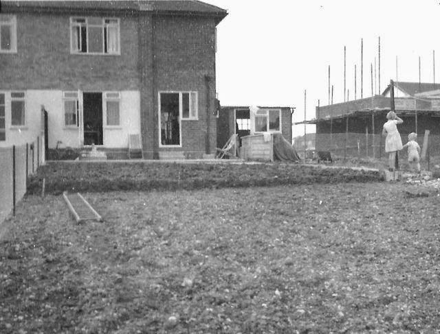
Even in the earlier days of photography, at the beginning of the 20th century, moving to a new house – meaning a different home for your family or a newly-constructed dwelling – was a reason for celebration.  If the house owner did not have a camera, a photographer might be hired if this could be afforded.  The result would be a record of at least some of the family at their new abode.  There was an explosion of camera ownership after WW2, and more informality too.  Opportunities arose to take a photo or two "to finish up the roll".

The rear of 189 The Ridgeway in 1959
Last week Martin contacted the blog because he had spotted the feature about The Quadrant.  This in turn alerted him to a photo he still has which was taken at the Ridgeway house (number 189) his family moved into in 1958.

"It shows the back garden, not much more than a bit of farm land enclosed by a chain link fence, and the rear of the house.  The house under construction next door is the detached corner property (187) at the junction with Packhorse Close.  My father spent a year or so landscaping the garden to combat the slopes, much of which is still in evidence today and can be seen via Google Earth."

Previously Martin had said, "I remember the early days of The Quadrant well. Butler's butcher's shop had sawdust on the floor and a separate payment booth at the back of the shop.  The shop boy then brought your newly-acquired joint on a bike direct to your door later in the day.  I later did a paper round for Martin's, the newsagent, from 1970 to 1974, when Mr Thompson was the proprietor.  Most of the proceeds was spent in Drummonds on Airfix kits.  Great days."

I am pleased that more recollections are appearing about Marshalswick, so here are a few more prompts.  Maybe someone will remember  the old concrete scout building, youth club activities, adventures in Chandlers Wood, the old farm house, ponds, the controversy over the nearby waste tip and the greater controversy about proposed new housing at Jersey Farm and a supermarket (Key/Sainsbury).  Oh, and the early years at Marshalswick School, and Wheatfields, St John Fisher and Skyswood schools.

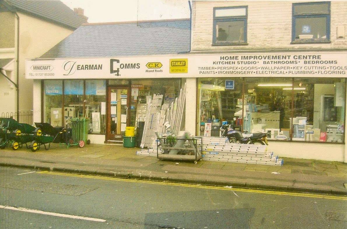
Dearman Gomms just before the closing-down sign appeared.
The closure notice of Dearman-Gomms in Camp Road coincided with the discovery last week in an issue of Herts Advertiser in 1970, of a feature article titled "Everything for the Keen Handiman"

"Just over 11 years ago John Dearman gave up a secure job in his father's firm, sold the house he had built himself, and with the proceeds bought some broken-down shop premises in Camp Road.  That was the first of two major decisions which changed his life.  He and his wife ran the shop as a grocery for the first three years [similar trade to the Tuckett's who were there previously].  It became more difficult to make a living out of the shop as competition from supermarkets increased.  Finally, Mr Dearman made the second decision which changed his life.  A practical man himself he foresaw the do-it-yourself boom which has materialised in the last few years."

That success story lasted until 2014!

Sunday, 26 October 2014

Exhibitions and conferences

The group of volunteers who have been researching the community of Smallford and the history of the branch railway between Hatfield and St Albans, celebrated a significant milestone last Wednesday.  At the University, where many meetings and workshops have been held during the past two years, we all gathered for the 'big reveal': the exhibition called Bringing The History of Smallford Station to Life.

It was appropriate that the celebratory evening was held at the University, the home of the Heritage Hub, which has provided so much support to the project.

This was the first occasion on which members of the project team were able to see the compete range of the research to which they had contributed, and the first occasion for their guests as well.

Although there is no immediate prospect of the exhibition being available for a season, there will be 'pop-up' opportunities at other events during the coming year.  We will publicise these pop-ups on the SAOEE website.


Yesterday, another significant event took place at Verulamium Museum: the fourth in the series of Autumn Conferences arranged by the St Albans & District Local History Network.  Over fifty representatives of local history organisations and groups came together to hear presentations by specialists in their field, on a coin find in London Colney, St Albans boundary extensions, the University's Heritage Hub, the role of Scouts during WW1, activity in the city during the 18th century, a report on the Museums' collections, a biography of John Griffith, and the history of Rothamsted Manor.

The Network is a loose amalgam of those people who have an enthusiasm for their local history and environment, whether they are part of a group or organisation, or whether they are keenly interested on a particular project, working on their own.  We do not 'belong' to the Network, but by contacting the organising committee on sanetwork@me.com you can add your contact details to the database, which is used to communicate details of events, queries about aspects of research, and of course details of the Autumn Conference each October.


Wednesday, 15 October 2014

New Generation Oaklands

The name Oaklands first became a location on the east side of St Albans in the early 19th century.  Before that the buildings, no longer extant, had been known as Three Houses at least as early as the 14th century.  William Knight purchased the land and that part of Oak Farm on the south-east side of Sandpit Lane, on which to built his mansion and establish a farm.  It is possibly the Oak Farm stub that gave Mr Knight the idea for the name of his mansion.

The mansion ceased to be purely residential at the outbreak of WW1, when Italian POWs were based here, as well as troops in training.  After the war the entire site came into the ownership of Hertfordshire County Council as an agricultural institute, later college.

Since WW2 there have been countless re-organisations of tertiary education and the current version is an amalgamation of several former colleges under the unfortunate name of Oaklands.  I only say unfortunate, because a multi-campus institution with the umbrella name of one of its, then, non-central locations, has inevitably confused large numbers of potential students and visitors, requiring the Oaklands site of Oaklands College to have the subordinate title of Smallford Campus, even though it is not in Smallford.

Detail of part of the south elevation at Oaklands Mansion.
The college's move from central St Albans to its new hub at "Smallford Campus"  involved a substantial upgrade of existing buildings, and  the construction of new ones too.  The plans had been agreed, and funding prepared, by the previous government, but the present government removed funding support as part of the austerity plans, which rather left the college searching for solutions.

Although the answer was seen in the development of part of its estate for housing, in fact housing had always been part of the mix, although not quite as extensive as now intended.

The residential proposals are controversial for three reasons: firstly because most of the estate is within the metropolitan green belt; secondly, because it has been recognised as a site for future housing in the new draft District Plan, now out for consultation.  Finally, it is controversial because there are residents in modern houses nearby who thought they would always look out onto green pastures, and now find that they may not.

The new District Plan does identify the proportion of the entire estate to be used for housing, and identifies a need for a two-form-entry primary school.  This in itself is interesting because the residential proposals would not, by themselves, require a 2FE school.  The cushion, presumably, is being provided because there is little flexibility within the remaining schools to the east of the city; will provide places for Smallford children, who currently have no nearby school; and possibly the council is looking towards the two other substantial housing proposals: Coopers Green Lane and Little Nast Hyde.

The rather neglected East Drive and lodge.
What possibly exercises the minds of many people already living nearby is the capacity of Hatfield Road and Sandpit Lane to cater for the number of new homes and their occupants' cars.  The District Plan does raise this issue, and the need to make improvements, but the only specific reference is to intersections.  The is no detail on the need to increase the capacity of these key arteries.

It is clear that with the current university population, the planned student/tutor increase at Oaklands College, the new homes destined for Beaumont's south field, and the three residential developments mentioned, it is not just higher-capacity roads and improved junctions which will be required.  These roads lead to other places, especially the centre of St Albans.  What will be required is a sustainable transport policy; a different approach to travelling.  Otherwise travelling is the last thing we will be doing in our cars.