Sunday 27 December 2020

Villas Past and Present

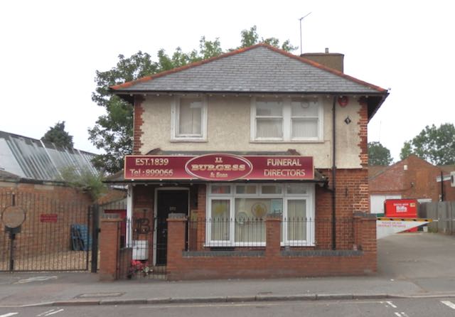
 You can imagine that, as soon as the western part of Beaumonts Farm was offered for sale in 1899, development plans emerged along the Hatfield Road's north side frontage.  To begin with it was probably limited to a few marker posts in the ground at the eastern end where land narrowed towards Beaumont Avenue.  Almost immediately a six roomed villa was erected (number 385 before the 1930 re-numbering, and named Innerleithen).  From new until a few years ago it has only been occupied by two households,  William Cowley, an elementary school teacher until around 1919; and then George Butlin followed by his daughter, Doris.  

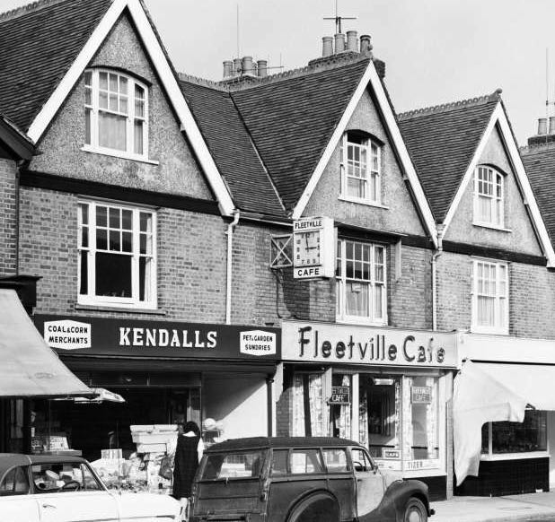
The five villas erected prior to 1910.
COURTESY GOOGLE STREETVIEW

Two further villas, 387 and 389, followed quickly, 389 being occupied by Alexander South, a tailor's cutter at the Nicholson coat factory in Sutton Road.  There was space for two more properties, the second having a triangular plot, both of which were finished c1910. Villa number 385 is clearly identifiable today as it is adjacent to the eastern boundary of Queen's Court flats, although these won't reappear in our story until much later.

In our previous post we noted the growth of the former Currell's garage and the widening of its plot to accommodate, initially an exit drive for the British Road Services trucks, and later a further property for parking up a number of cars – still used for this function today.  The two properties absorbed in this way had been occupied by George A Curgenven, a railway engine driver, and next door in a bungalow, his son Arthur George Curgenven, who was a postman. The properties are visible on the extreme right of the middle  image in the previous post, but both had been demolished in the 1950s and 1970s respectively.

The initials FP locate the Alley (originally known as Crosspath). The five villas shown in the top photo are bounded in yellow; the two villas sited on the remaining land (bounded in red) are near the
Hatfield Road boundary and marked in blue.
COURTESY NATIONAL LIBRARY OF SCOTLAND

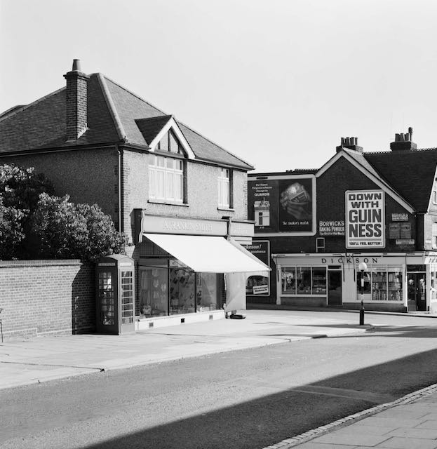
View of the five villas from the Ashley Road corner.  Behind the man and dog are the two villas
marked in blue on the map above.  In the distance is the chimney of T E Smith's printing works.
COURTESY ST ALBANS LIBRARIES (HALS)

We are therefore left with a sizeable site bounded in red on the map above and on it arrived two villas (framed in blue) somewhat larger than the earlier five to the east: 383 named Balgowan as early as 1903 and 381, named Waratah a couple of years later. It seems inevitable that both, with their expansive gardens, orchard and tennis court, would eventually be ripe for further development.  A development company known as Parkfield Developments acquired the legal and financial interests in both properties and submitted proposals in 1935 for a number of shops fronting Hatfield Road, an access road and blocks of flats between the shops and the Alley.

The Council,  empowered by a number of town planning acts in the 1920s and 30s, considered the applications and refused them in 1935, and again in 1937; making it clear it thought Fleetville already had enough shops and adding more would contravene the Ribbon Development Act.  Quite apart from the safety issues around the proposed access road, and close to the busy lorry access road.

Parkfield, in an apparent attempt to force the issue, began the process of demolishing the existing houses, although site clearance was not complete by the declaration of war in 1939.  The Council acquired the site as a base for the emergency National Fire Service and a building was quickly put up on the west side of the site.

Aerial view of Queens Court (centre) with the new flats replacing the 1959 library to the left
and the five original villas approaching the double roundabout on the right.  The straight line of the Alley from the double roundabout disappears in the group of trees towards the left edge of the
photograph.
COURTESY GOOGLE EARTH 

The eastern block of the award-winning Queen's Court.

The land remained unused, and the NFS building vandalised, for a further seven years after the war finished, and the Council then gave itself planning consent for three blocks of flats with an access road (but no shops!), work beginning in 1952.  The imminent Coronation prompted its naming Queen's Court; and the design received a national architectural award.  The original build had open passage entrances and staircases and the only subsequent alteration had been  the addition of front entrance doors to each block.

Both the Fleetville branch library (shown here) and Cell Barnes Lane branch library are now
closed.


The former library site, at the western edge of the site acquired by the city council. New flats built c2012.

One small part of the site was reserved for a branch library when the city's libraries were under its control. This opened in 1959, having been lobbied for by ward councillors since the 1920s, but is now replaced by a small block of flats.

The whole of the north side of Hatfield Road has now been explored, from The Crown to Beaumont Avenue, which the author hopes readers have enjoyed.  After a suitable interval we will turn our attention to the south side of the road from The Crown itself, along a similar distance to Ashley Road.

Friday 18 December 2020

The Garage

 Between the twin shops, which were the subjects of the previous post, and the Beaumont Avenue corner were a small number of villa homes which had been built before the First World War, although these are not for us to discuss here.  To the east of the two shops were two adjacent plots which had been acquired by Mr A Johnson of Grosvenor Road, presumably for investment, for they remained empty until the mid-1920s.  Two further properties,  a detached house (233) and a bungalow (235) and both owned by George and Arthur Curgenven respectively, were eventually subsumed in to the business originally launched by the Currell family. There was also a triangular plot at the rear, next to the alley (Crosspath) which belonged to the Oakley family of Sheephouse Farm, London Colney.

A pair of plots purchased by Henry and Sydney Currell in the mid 1920s is bordered in orange.  To
its right is a house and bungalow built at the same time but eventually demolished to enlarge the
commercial premises; the house to allow for an exit from the site, and the bungalow to provide
multiple parking for car sales and rentals.  The green plot was originally owned by the Oakley's of London Colney. Map published in 1937.
COURTESY NATIONAL LIBRARY OF SCOTLAND
What would happen here was connected with Henry George Currell who, in 1907, moved with his family from North Mymms to Burnham Road and then Princes Road (later renamed Woodstock Road South) in Fleetville.  A son, Sydney George, was born in 1909, and in 1927 father and son jointly set up a haulage and motor repair business by acquiring the two plots 229 and 231 (the orange block in the map above).  At the road end a house was constructed for Sydney and from which the business was run, while workshops occupied the rear and later expanded onto the former Oakley nursery garden (edge in green on the above map) as Currells' business grew.  People walking along the alley always had a clear view of the business premises, and foliage permitting, would still do were it not for the size of the current building.

When first opened in 1927 there was just one access, but as the number of visiting vehicles grew a one-way system developed with a separate exit on the eastern side of the site, the space for which required the demolition of another house.

Expansion of the business widely advertised in the Herts Advertiser, this
in 1937.
COURTESY HERTS ADVERTISER
Given the space, and the servicing facilities available, the business expanded in the mid thirties, first into house and office removals, and a little later into a carrier business, which made efficient use of vans and trucks which might otherwise lay idle.

This photo was included in the previous blog.  Of the three properties to the right, the first was 
Sydney Currell's house, the second, belonging to George Curgenven, was demolished for
the exit driveway, and the bungalow far right belonged to Arthur Curgenven and was
demolished to provide multiple parking for rental cars.
COURTESY ST ALBANS MUSEUMS
Currell's remained under family control until 1948 when the wide-ranging nationalisation British Transport Commission was formed and road haulage was rebadged British Road Services (BRS). Most of its vehicles were painted National green or National red.  From then on the comings and goings along Hatfield Road became more frequent and vehicle sizes larger.

BRS transferred to the Transport Holding Company in 1963 and was  charged with disposing of those premises not required.  The site was soon sold to Valliant Coaches and then Smith of Maddiston Haulage.  Before the end of the decade we were all offered the opportunity of calling in as Sydney Currell's house was taken down and the Hatfield Road Petrol Filling Station opened, initially with attended service.


Five separate plots eventually became one transport hub!
COURTESY GOOGLE EARTH.
Competition from a duplicate station across the road owned by St Albans Co-operative Society on its former bakery site eventually ensured that neither survived in the face of increasingly larger petrol stations owned by the major oil companies.  The former Currell's site turned its attention to car sales and to vehicle hire, which is why we had Milcars and Thrifty Car & Van Rental more recently.

This site has certainly entertained a busy schedule in the past (almost) one hundred years. 


Wednesday 2 December 2020

Traditional Semi-detached Pair

 After taking a short break from exploring the north side of Hatfield Road, and having reached the recently redeveloped former trading premises, we discover a pair of semi-detached homes erected in the mid 1920s.  They do not appear on an OS map until the 1937 edition but were occupied as residences during the 1920s.

Circled are the two shops which are 225 and 227 Hatfield Road, first erected in the 1920s as
private residences, but only remained as such for a few years.  To the left of the circle is the detached house, until recently Bugess & Co, and to the right the car franchise.
COURTESY NATIONAL LIBRARY OF SCOTLAND
As has been usual along Hatfield Road it did not take long for conversions to take place into retail premises.  Let's begin with recent trading for those of us who walk past the shops today. Number 225 is a convenience store which is akin to what the shop has always been identified with.  The name on the fascia for much of its time had been Leon Turner, a business taken on by Leon Ralph Turner, whose family lived in Sandpit Lane, close to the Beaumonts Cottages.  Eventually, the shop became part of a franchise, but it has always remained a local convenience shop strategically located at the eastern end of the "mile of shops" along Hatfield Road.

The two local shops, each with the original arched front doors still visible and the modifications
needed to convert to shop frontages.  Photograph taken in 1964.
COURTESY ST ALBANS MUSEUMS


Number 227 has had more opportunist owners in recent years, now supplying small office needs, but for most of its time customers came here for their basic ironmongery and domestic goods sold to them by Mary Blackstaffe; her husband meanwhile working as an engineer.

There were very little in thew way of rear garden spaces as most were accommodated by the factories which were the subject of the previous post.

Recent view in which cars are parked on what would have been the front garden space had the
properties remained residences.  Note that the blue canopy to the right replaced the former
detached house described in the next post.


The photograph taken in 1964 shows a neat and uncluttered frontage to the shops, in spite of the open air "showroom" in front of Blackstaffe's.  My own recollections of purchases from the 1940s and 50s included slices of carbolic soap from a long bar, washing crystals sold by weight in paper bags, and household candles – essential during the times when electric power cuts were a regular occurrence.  The times have treated the frontage reasonably well.  Number 225 lost its original front door (access was via its narrow sideway), becoming part of the shop converted from the original front living room.  Number 227's display area spilled into its hall while leaving the structure much the same.

When closed the building presents a very different
atmosphere.

Today the plot boundaries of many properties are not so clearly defined as usages have changed, and this includes the fence boundary to the right of number 227, the lack of which today gives a false impression of the vehicle access width past the next property I will describe; the one which until recently belonged to Milcars.  That, and the triangle of land behind will be for next time.  Although an attempt was made in the 1930s to add a further parade of shops, such expansion did not come about; Turner's and Blackstaffe's effectively calling a full stop to Fleetville's shopping facilities.


Saturday 31 October 2020

Across the Boundary


The red bounded area from the 1922 OS map is the part of Hatfield Road featured in this post.
Courtesy NATIONAL LIBRARY OF SCOTLAND

The triangular plot is the former laundry site following demolition, with the farm track to its left from the roundabout. To the right of the green patch is the detached house until recently owned by Burgess funeral directors.  Behind this are the factory buildings.  The semi-detached shop building in front of them will be part of the next post.
Courtesy GOOGLE EARTH

The same area as the top map but from 1937
COURTESY NATIONAL LIBRARY OF SCOTLAND


The hedge line of the field marking the end of Thomas Smith's land, and on which Bycullah Terrace was constructed, left just enough space for a short road of terraced homes – Arthur Road – reaching the rear boundary of Smith's field and the extant public footpath. At the Hatfield Road eastern corner Mr Smith had constructed an employees' institute, available for "wholesome" activities at lunchtimes and evenings, each day except for Sundays, when a Sunday school was sometimes available.  

Foundation stone on the Institute building, located to the right of the Arthur Road street place, hidden behind more modern brickwork in the photo below.

The Institute photographed after modernisation in 1964.
COURTESY ST ALBANS MUSEUMS

From 1914 the Institute was converted into a billet for soldiers under training in the district. With the closure of Smith's for printing, effectively after 1918, the building was fitted out as a small printing works under the management of J W Vernon until the 1960s.  A non-slip tiling product was then made before becoming an office building, confusingly called Quadrant which replicated the shopping district at Marshalswick.

The cottage which would form the start of the laundry.  Was this intended to be the left side of
a pair?

At this point was the field boundary and a private track marked the end of building development for much of the first decade of the 20th century except for five villas near Beaumont Avenue.  The track is a continuation of Sutton Road and Camp View Road on the Beaumonts Farm side of the dividing hedge.  Today it survives as Montague Close, but in 1907 a small cottage with front bay windows was built for Mrs Turner.  Behind this, with access from the track was workshop accommodation for William Moores' farrier and blacksmith business.  Moore's was contracted to both Oaklands and Beaumonts farms.  The coach building business of Arthur White joined him at the end of the track.

Hatfield Road looking towards Beaumont Avenue c1920.  The cottage is on the left, with the
extended laundry and the detached house after that.
COURTESY ST ALBANS LIBRARIES/HALS

After the First World War the cottage was taken over by Rosa Walker and run as a laundry, the land being owned by Samuel Handford.  He constructed a basic iron frame and brick building next to the cottage.  Large windows opened onto the footpath so that potential customers could view the work being undertaken inside. Hatfield Laundry took over the work and the process converted to dry cleaning and a same-day service.  In the 1960s competition from elsewhere resulted in its closure, and Charles Gentle opened a builders' merchant service and then specialised in tiles and plumbing products.

The Laundry and Gentle's share the building in 1964.
COURTESY ST ALBANS MUSEUMS

The Fleetville Vintage Emporium occupies the site.
COURTESY FLEETVILLE VINTAGE EMPORIUM

For a number of Fleetville people the building's most interesting period was yet to come as it became home to a collective of traders in "odds and ends" – collectables – and their enthusiastic followers.  It was known as the Vintage Emporium. The Emporium attracted many regulars, and while passers by may have wondered how quiet it sometimes appeared to be, it should be remembered there were other sales areas in former workshops at the rear.  There had been long-standing plans to use the land for housing, but gaining permission was a complex process.  The new development is now complete with a mix of one and two bedroomed flats. The former Emporium has now relocated as Fleetville Emporium to Hitchin.

The detached house, called Mariposa, for Thomas Oakley.  Factory space behind.

The next plot became number 223  on which a detached house, originally named Mariposa, was constructed. First built on in 1910 the house was owned by Thomas Oakley. The family operated a small timber yard to one side and this plot was separated and became 223a.  At the end of WW2 when many factories relocated to St Albans, the Oakley's timber yard became home to Mulcare Messer, which manufactured Qwiz Darts, and the builders' operative Cockcroft & Preece, also utilising space behind the detached house, which in recent years had been the base for Burgess Funeral Directors.  223a is now being developed for residential use as Napier Court, and Burgess has moved to premises opposite Wynchlands Crescent.

New development, Montague Close.

From this point there was a push to add more homes along the street, although we are not quite finished with an industrial patch along Hatfield Road as the new homes were soon transformed into further commercial premises, which we'll explore next time.

Saturday 10 October 2020

Bycullah

 Let's begin with the name of the row of shops which is west of Arthur Road.  When the printing works arrived in 1897 we would have been looking towards the north of Hatfield Road and to a field extending from Andrews greengrocery to the access road, now the new Montague Close.  Print firm owner Thomas Smith had these properties built, and named the row Bycullah Terrace.  His home was a very large house called Bycullah House in Bycullah Road on the wealthy west side of Enfield.

The terrace c1908 with the grocer on the left corner of Tess Road, now Woodstock Road South.
In the distance only one house, now replaced by the blue flats, had so far been built on the south side, east of Sutton Road.

The same view c2000. The road has been moved slightly south to allow space for parking
outside the shops.

On weekdays the parade would be busy in the early morning and early evening with employee
arrivals and departures at the printing works; and workers or managers visiting the Dining Rooms
or the Institute (right) during the midday break.
COURTESY DAVID MILES

The terrace as built consisted of three houses, intended for managers of the print works, set in the centre of the terrace, and three shops on each side of these homes.  They were to serve the "Ville" of homes being built in the rest of the field.  As occurred elsewhere in the Ville many of Smith's houses were let to non-employees.

Only one impediment obstructed the buildings, a milestone for the toll road, but the buildings were arranged to sit immediately behind the object (see my blog "A Mile is Not a Mile" 1st February 2020, because the milestone is certainly not in front of any of the shops today).

In 1964 the area is busy enough to require a pedestrian crossing, which was set out for the
Ballito works and the Central and Fleetville Schools.  Today the area is crowded enough for a second crossing in Woodstock Road South.
COURTESY ST ALBANS MUSEUMS

The three houses in the centre of the block remained residential until 1930, although there were short periods when unoccupied, the house which is now the optician began as Fleetville's first physician and surgeon, William Graves.  A year before the arrival of Dr Frederick Smythe at Fleet House (see last week's post), he  practiced at Bycullah Terrace.  Next door was Joseph Hassall, superintendent of the County police, responsible for the police station in Tess Road, also as referred to in last week's post, although the house remained unoccupied most of the time before 1911.  The third house remained completely domestic until  the mid 1950s, and the ground floor wasn't fitted out as a proper shop front until after 1960.  It was Kendall's Coal Merchant, and the author recalls entering through the street door and paying the family fuel bill in the front parlour.

This picture was taken a few years after the house was converted into a shop for Kendall's.
COURTESY STEVE KENDALL

Percy Hall's hair salon to the left of the first house, which would later be converted for Kendall's.
COURTSEY JACKIE ALDRIDGE

The first two houses had an earlier conversion shortly after 1930.  A H Smith opened a bakery; this later became A & E Spurrier, who was also a baker, then ABC Sandwiches, before the current optical services.  In the middle house Mr Dellar tried running a Wallpaper shop for a short time.  It was also Percy Hall's hairdressing salon before he moved along the road, but for the majority of its life it has been a grocer: Pollard's, Green's, Key, and Saar Convenience Store, today using a vinyl on the front window to replace an actual window display, as is the modern trend.

If the shops were intended for the Ville residents it will be interesting to discover the extent to which they were for everyday requirements, and whether the same applies today.  Of the western group of three, the corner establishment remained a grocer for a full century: Charles Philips, Frank Lovegrove, Leslie Bennington and Dixon's.  It is only in recent years that it has offered cultural foods.

Mrs Blakeley and her father outside her shop which generations of children identified as the "sweet shop"
COURTESY CHRIS WARD

Next door a general shop, which would be known as a confectioner – children would know it as a sweet shop and their parents would purchase their tobacco products.  P H Stone, who started at Primrose Cottage shop, where the Rats' Castle PH is today, moved there and then transferred to 157 Hatfield Road.  Mrs Blakeley arrived in the mid-1920s.  William Grace, a manager from de Havilland Aircraft Company, retired from that role in 1946 and took on a quieter role running the shop. Around 1970 it became a dry cleaners and now, with the internal walls removed it is Alban Locksmiths.  Retained is the step between the former front and rear rooms, as the the left shops were built on a small hill (as seen in Woodstock Road South).

The third shop began as William Helmsley's stationer, drapery and the little district's post office, before being taken over by John Smith, of the same family who moved to new premises as Rankin Smith c1930, since when the Warwick family ran the shop as Fleetville Fisheries, with an open front and roll-down shutter.  Today the shop is one of the many shops owned by Simmons, the bakers.

A 1964 photo showing Kendall's as a fully converted shop, and the Fleetville Cafe, tables in the windows and a corner counter on the left. Many residents would have recalled the clock above the
shop which often only showed the correct time twice each day!
COURTESY ST ALBANS MUSEUMS

The first of the three eastern shops has always been the local cafe (in earlier times known as Dining Rooms).  It is only from c2016 that it became Fleetville Fish Bar and then Nonna's Pizza.  The middle shop of this group (217) spent the first five years or so as an ironmongery, and was then the parade's butcher, in the care of two families: James Finch and then Horace Presence. Now it is a barber's.


On the Arthur Road corner during the occupancy of the
chemist run by H Bowman.

Finally, on the Arthur Road corner, this shop had three separate lives; first as a greengrocer, then a bookmaker and repairer, and finally H Bowman, the chemist, in roughly equal measure.  Intended for part of the leisure trade in modern times anglers are now served.

Most residents today consider Fleetville to be a significantly larger area than when the Smith Ville was developed.  But it is generally accepted that Bycullah Terrace and its environ is the true heart of Fleetville, partly because it was Thomas Smith who named it so, and this is where the first bricks were laid.

Although there are nine roof elements, one for each property,  two of the three houses share a single wide canopy, with a smaller decorated brick elevation fitted with triple casements each.  This is best viewed from the opposite side of the road.
COURTESY GOOGLE STREETVIEW


Wednesday 30 September 2020

Missed the Flicks

 Not only were there no houses on what later became the recreation ground, but there were few homes built on the T E Smith land  between Royal Road and Tess Road (now Woodstock Road south) either.  A row of  six small homes appeared in Royal Road, and one detached and two adjacent semi-detached houses on the west side of Tess Road.

1922 OS map showing the school and (circled in blue)
the police station and police houses.

1922 OS map showing the Hatfield Road block outlined in red.
MAPS ABOVE COURTESY NATIONAL LIBRARY OF SCOTLAND

This was the point, in 1906, when the County authority concluded it needed to take decisive action in providing services for this extensive series of private residential estates, and with more to come; open spaces, education facilities and the Police Constabulary were definitely not part of the brief of house builders.  The County moved its police station into the first house in Tess Road with the Sergeant and Constable living next door.   In the 1970s all three buildings were demolished to provide land for parking and a children's nursery.  The largest land acquisition came to provide – at last – land for an elementary school; this came following pressure from countless parents who had to send their children "over to the Camp School".

Royal Road to the left; Woodstock Road (Tess Road) to the right. The little car park and the
building beyond are the site of the former police station and police houses.
The 1922 OS maps (top images) show a broad band of vacant land adjacent to Hatfield Road, and it remained in that state until c1930 when another service lacking in Fleetville was finally provided: more adequate medical support.  While there was a doctor and a dentist at The Crown end, it was not until shortly after 1930 when Dr Smythe built a detached house and surgery at the corner of Royal Road.  It still sports the original name of Fleet House, and it was distinctive in possessing a corner front garden.  Although it sits snugly into the Hatfield Road streetscape it actually belongs to Royal Road. Fleet House was later converted into a pair of flats and the original rear garden plot was then used for a small detached house, 2B Royal Road.

Fleet House to the left and the parade beyond in 1964.
COURTESY ST ALBANS MUSEUMS

Post-conversion view of Fleet House with added access to ground floor flat.

However, Dr Smythe was beaten into second place by the arrival of John Smith, stationer and draper who previously ran the third shop in Bycullah Terrace, which also had a corner devoted to a Post Office.   It had been a busy shop and Mr Smith sought more space for his trading. Purchasing the corner plot at Tess Road he engaged the building partnership of Goodwin & Hart to create what everyone still knows as the Fleetville Post Office.  The original garden plot faced Hatfield Road, but an extension to the Post Office and drapery was constructed on the garden c1960.  This is now the separate business of MediVet. 

The Post Office still with its rear garden and name fascia A Rankin Smith in 1964.
COURTESY ST ALBANS MUSEUMS

The shops c1960.  The extension being constructed in the garden of The Post Office.
COURTESY JACKIE ALDRIDGE

The trend in the 1930s for a single building combining several shops, and also identified in a recent post, was continued here where three standard width units and a pair of half-sized units were built.  First to open was Percy Hall's hairdresser departments for both women and men.  Mr Hall had previously opened his first salon nearby in Bycullah Terrace and had others around Fleetville at different times.

Recent view of the shop which began as Harpers Motors and later St Albans' Scooters.

When Norman Harper first opened his Motor Sales showroom as late as 1939 the legal documents reveal this block of land had still been in the ownership of the estate of Thomas E Smith from the former printing works opposite.  Although now a phone repair shop the street elevation still has the original bracket arm for frontage lighting; street lighting in the 1930s was still quite poor.

The two half shops began as London Central Meats and a studio photographer.  After the Second War they were Baxter's Butchers and Garrard Fruiterers; and along the sideway to the right was a signwriter's business for S T Broad.

The Post Office with shops beyond.  This is where building activity took place in 1912 to create
Fleetville's cinema. This is the orange block outlined on the second map above, and occupied
a wider plot than had been paid for, according to the court report in the Herts Advertiser.
COURTESY GOOGLE STREETVIEW

A plan and front (Hatfield Road) elevation drawing of the cinema.  Not a single showing
took place, and no sooner was the building up than, by court order, it was taken down.
COURTESY HERTFORDSHIRE ARCHIVES & LOCAL STUDIES

So, where do the flicks come in?  Well, the building came – and went – so quickly that not a single performance took place. Russell Edwards living in Granville Road claimed to be a showman, and saw a business opportunity which wasn't entirely legal and put up a secondhand tin building as a picture house/cinema.  Without using his own funds this serial mischief maker assured an investor that the cinema was already open and operating profitably and attracting patrons in numbers which, in fact, could not possibly have been accommodated.  In fact it was just a pile of tin and iron lying on the ground and the men engaged to erect it were sometimes not paid.  Creditors caused Edwards to be taken to court – again, and the court ordered that the building, so close to opening, should be taken apart and sold to defray court costs.  When did this occur? In 1912, so becoming the first occupier of this block. And where was it?  It all happened on the plot which is still Fleetville Post Office today.  

Sorry you missed the show!

Next time we'll trace the story of the most well known Hatfield Road trading quarter, Bycullah Terrace, and discover the origin of its name.


Wednesday 16 September 2020

For the People of Fleetville

Red: three fields formerly owned by the Grammar School.
Blue: field purchased by T E Smith for the Fleet Printing Works.
Orange: field purchased by T E Smith for his Fleet Ville housing.
Green: Part of the same field left undeveloped and acquired by Charles Woollam.


Recent aerial of the recreation ground during a dry summer period.
COURTESY GOOGLE EARTH

 We have now reached the end of St Peter's Farm where the property boundary lines up obliquely from the main road.  The former fields outlined in red on the above map identifies land which was owned by St Albans Grammar School and managed for it by the Verulam Estate.  The blue field was acquired by Thomas E Smith for his printing works in 1897 and he acquired the green and orange field opposite to lay out a hamlet for his employees.  

Others were also laying out streets and houses nearby on the former St Peter's Farm, and so Smith did not use all of his land – the green part of the field on the north side of Hatfield Road – otherwise there may have been a further street of two of small homes had the demand evolved.  You will see that there were no homes on the west side of Royal Road.

William Bennett, well known in the building trade, had rented at least part of the green field to store building materials, including bricks, which he needed for his construction activities in the Slade building estate.

In 1912 Charles Woollam, mill owner and a trustee of the Grammar School that had sold two of the three fields to Thomas E Smith in order to fund the expansion of the school adjacent to the Gateway, purchased the green field from the Smith estate using his own funds.  He had noted with some concern that Fleetville was growing quickly and no land had been allocated specifically as open space for the use of this district's residents. He gifted this land to the City Council in 1913, the year in which the authority had taken over responsibility for Fleetville from the Rural Council. A covenant protected the use to which it could be deployed, for the recreation of the people of Fleetville in perpetuity.  By name it was initially called Fleetville Pleasure Ground or Playing Field; later became known as Fleetville Recreation Ground, or Rec, but is now sometimes referred to as Fleetville Park.

No sooner had the council prepared the ground, built retaining walls and installed railings (some of which remain in place) than there was a call to dig it up for emergency allotments.  After some disagreements the allotments went instead to the field where Fleetville Junior School is today.

Pre-WW2 family photo, with the school as a backdrop.  This was before the recreation ground
railings were removed on this side.  Today the seat is occupied by part of the front of the
Community Centre.
COURTESY FLEETVILLE INFANT SCHOOL & NURSERY


For the next 25 years the Rec was rather bland with just one set of children's swings near the Royal Road corner (chain locked on Sundays as was the custom in St Albans); and a public toilet block added in 1938, the same year in which emergency zig-zag trenches were excavated in preparation for war.  Gates in the fencing at bottom of Burnham Road gardens enabled quick access to the trenches.  Additional trenches were added in 1939 and 1940 for the benefit of the school; all were deepened to 8 feet, bricklined and covered, and fitted with electricity, heating and telephone.  They were accessed from steel doors at Royal Road with an emergency exit in the rec field, the latter can still be noticed in parched grass in hot dry summers.  A temporary day nursery arrived in 1942 for the benefit of mothers who worked in the munitions factories locally – this building is still in use as the Community Centre.  

A 1939 aerial of the recreation ground in the middle.  The 1938 open zig-zag trenches are visible.
So too is the diagonal footpath between the Hatfield Road and Royal Road gates. Within that
triangle is the new public toilets block and the children's swings.  Also clear is the grass wear from games of football!
COURTESY HERITAGE ENGLAND

The temporary wartime children's nursery, today used by Fleetville Community Centre. The car is
parked where once a ramp and steel door led below ground level to emergency shelters for the
use of children at the school.

Two further installations during the war were an ARP hut next to the newly opened toilets, and an emergency water tank located where the zip wire is today.

Recent photo of the recreation ground without its original pre-war hedge line resulting from
road widening in the 1960s.

Plan prepared by Design Team Partnership in 1989 for a proposed underground car park for 194 cars under the recreation ground.  It would have occupied the southern end, but the proposal was not taken forward.

Post-war the junior children took to using the field for games lessons, but this was frowned on by the city council who wanted their bit field back from the County Council. A line of young trees were planted beside the shops, and in the 1960s a corner of the main road was shaved off and widened on safety grounds; resulting in the loss of the original field hedge with partial replacement of the original boundary wall.  Children living west of the rec will recollect an informal access point via a couple of missing railings next to Andrews' greengrocery.  That short cut disappeared with the improvements!

A scheme came to light in 1989 for a 200-car underground car park with ramp and six emergency staircases emerging at regular points in the field, as well as a number of light wells.  No one appeared to have considered the impact on organised events and team games.  Anyway, the plan was abandoned.

In more recent times there has been activity equipment for children and young people right across the park, and although the toilets were closed a popular cafe and seating area has appeared.

Next time we shall continue moving eastwards to the later developments between Royal Road and Tess Road (now Woodstock Road south). It might have become an entertainment hub!